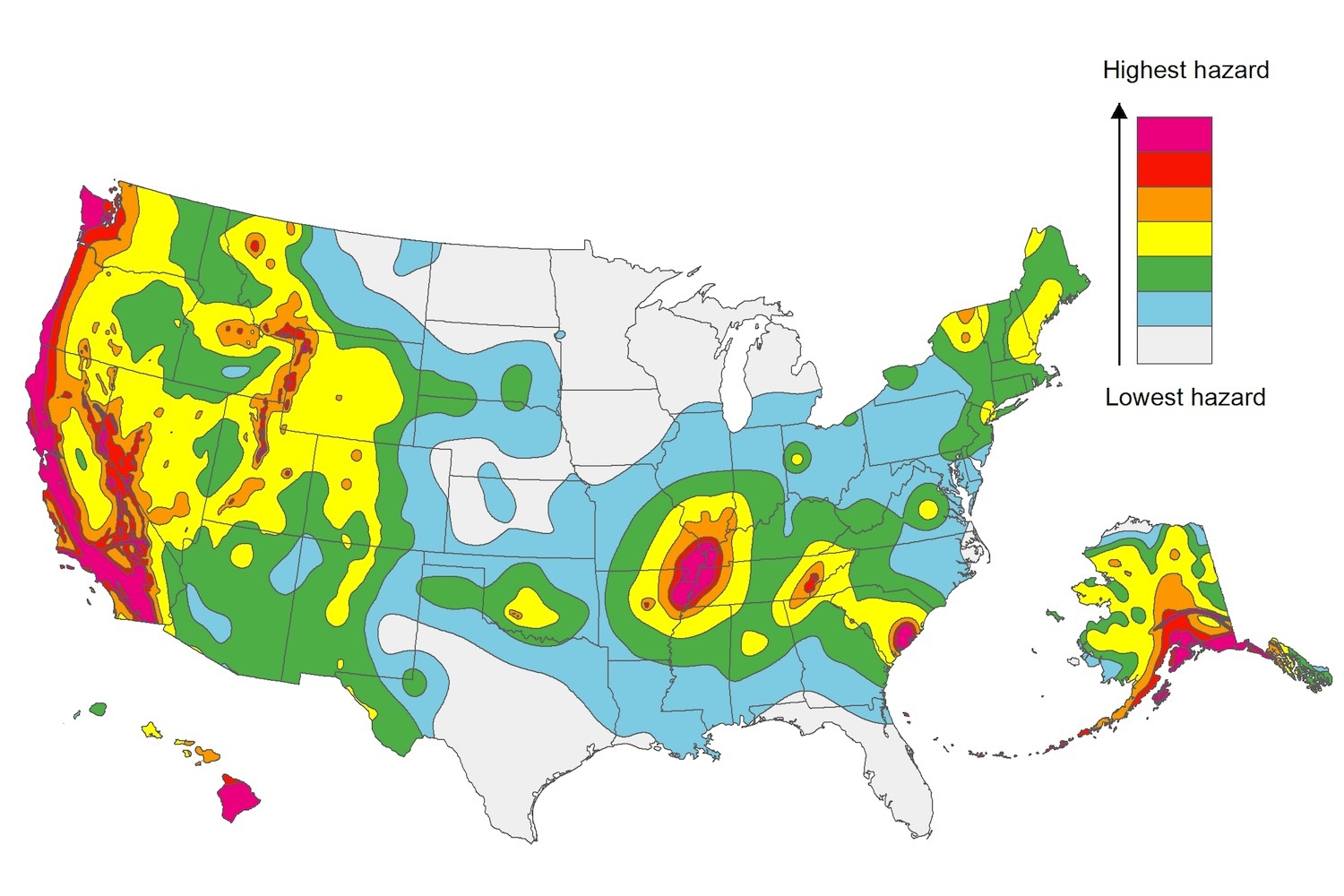
The U.S. Geological Service recently released an update of U.S. National Seismic Hazard Maps that reflect the latest analysis of where future earthquakes will occur, how frequently they may occur, and their strength.
While all states have some potential for earthquakes, 42 of the 50 states have a reasonable chance of experiencing damaging ground shaking from an earthquake in the next 50 years. Sixteen states have a relatively high likelihood of experiencing damaging ground shaking. These states have historically experienced earthquakes with a magnitude 6 or greater. The hazard is especially high along the west coast, intermountain west, and in several active regions elsewhere such as near New Madrid, Mo., and near Charleston, S.C.
The eastern U.S. has the potential for larger and more damaging earthquakes than considered in previous maps and assessments. This finding is due to what scientists learned following the magnitude 5.8 earthquakes that struck Virginia in 2011. It was among the largest earthquakes to occur along the east coast in the last century, and indicated that even larger events in the region are possible.
The maps are used in risk analyses calculated using factors such as population levels, building exposure, and building construction practices. These assessments are used for establishing building codes, in the analysis of seismic risk for key structures, and in determining insurance rates. They can also aid emergency preparedness plans, and private property decisions such as re-evaluating one’s real estate and making it more resilient.
(http://www.usgs.gov/blogs/features/usgs_top_story/new-insight-on-the-nations-earthquake-hazards/)
Related Stories
Wood | Apr 8, 2016
New LEED Pilot ACP designed to help eliminate irresponsibly sourced materials
Illegal wood is primary target to restrict illicit material in the supply chain.
Lighting | Apr 5, 2016
Lighting requirements for high-rise dwellings proposed for energy standard
The requirements would effectively eliminate incandescent and halogen bulbs.
Steel Buildings | Apr 4, 2016
AISI publishes Cold-Formed Steel Framing Design Guide, 2016 Edition
Updates 2007 edition; includes five comprehensive design examples.
Data Centers | Apr 1, 2016
ASHRAE releases publication on the impact of IT equipment on data center design
The book offers advice for designing structures in the fast-changing data center industry.
Codes and Standards | Mar 28, 2016
Occupant egress simulations that impact codes fall short, researchers say
Building evacuations in emergencies are too dangerous as a result.
School Construction | Mar 28, 2016
National report on school buildings reports $46 billion annual funding shortfall
Millions of students said to be learning in obsolete facilities.
Codes and Standards | Mar 25, 2016
ASHRAE grants fund human thermal comfort database project
Aim is to help better understand thermal comfort in residential and commercial buildings.
Codes and Standards | Mar 25, 2016
OSHA finalizes new silica dust regulations
Construction industry has until June 2017 to comply.
Wood | Mar 23, 2016
APA updates Engineered Wood Construction Guide
Provides recommendations on engineered wood construction systems.
Codes and Standards | Mar 23, 2016
Affordable housing advocates differ on micro-apartment policy
New York’s luxury micro units could be first step to developing affordable units.


