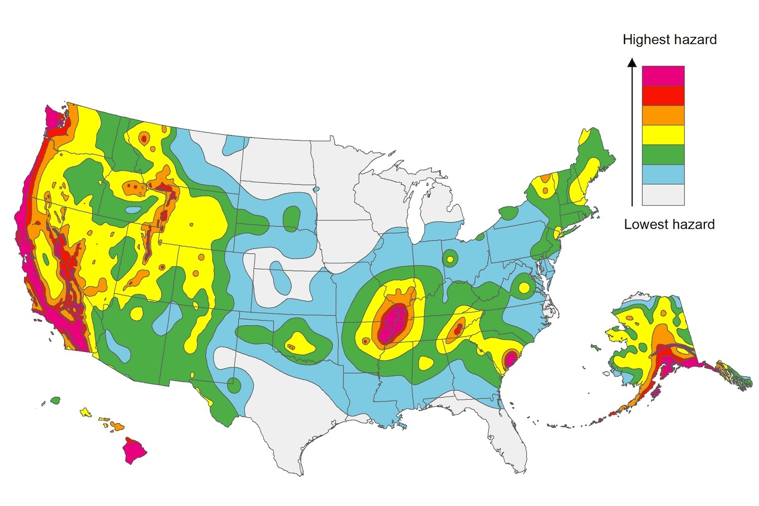
The U.S. Geological Service recently released an update of U.S. National Seismic Hazard Maps that reflect the latest analysis of where future earthquakes will occur, how frequently they may occur, and their strength.
While all states have some potential for earthquakes, 42 of the 50 states have a reasonable chance of experiencing damaging ground shaking from an earthquake in the next 50 years. Sixteen states have a relatively high likelihood of experiencing damaging ground shaking. These states have historically experienced earthquakes with a magnitude 6 or greater. The hazard is especially high along the west coast, intermountain west, and in several active regions elsewhere such as near New Madrid, Mo., and near Charleston, S.C.
The eastern U.S. has the potential for larger and more damaging earthquakes than considered in previous maps and assessments. This finding is due to what scientists learned following the magnitude 5.8 earthquakes that struck Virginia in 2011. It was among the largest earthquakes to occur along the east coast in the last century, and indicated that even larger events in the region are possible.
The maps are used in risk analyses calculated using factors such as population levels, building exposure, and building construction practices. These assessments are used for establishing building codes, in the analysis of seismic risk for key structures, and in determining insurance rates. They can also aid emergency preparedness plans, and private property decisions such as re-evaluating one’s real estate and making it more resilient.
(http://www.usgs.gov/blogs/features/usgs_top_story/new-insight-on-the-nations-earthquake-hazards/)
Related Stories
Seismic Design | Jun 28, 2016
ASTM International updates seismic risk standards
Expected to improve consistency of risk evaluation on commercial real estate transactions.
Codes and Standards | Jun 17, 2016
Feds publish framework for evaluating public-private partnerships
No single factor determines whether a project yields stronger benefit as a P3.
AEC Tech | Jun 17, 2016
Driverless cars could soon start impacting commercial, retail project design
Offsite parking and more space for valet parking lines are among the foreseeable changes.
Codes and Standards | Jun 17, 2016
Bay State moves toward single BIM protocol on state projects
Massport’s guidelines a step forward for integrated BIM initiative.
Multifamily Housing | Jun 14, 2016
San Francisco voters approve tougher affordability requirement on new housing development
Critics charge that the measure may backfire and actually reduce new affordable units.
Concrete | Jun 13, 2016
American Concrete Institute releases new Guide to Shotcrete
Includes information on application procedures, testing.
Healthcare Facilities | Jun 10, 2016
Top 10 health technology hazards include some influenced by space design
ECRI Institute’s annual list includes operational and workflow issues.
Codes and Standards | Jun 9, 2016
Supreme Court ruling could aid developers on properties containing wetlands
Unanimous decision allows landowners to take regulatory decisions straight to court.
Green | Jun 8, 2016
TD Bank Group's renovated Toronto office is first WELL-Certified project under WELL v1
The newly renovated 25,000-sf space achieved gold-level status.
Concrete | Jun 7, 2016
Concrete Institute publishes document providing concrete curing guidance
New curing monitoring techniques included.


