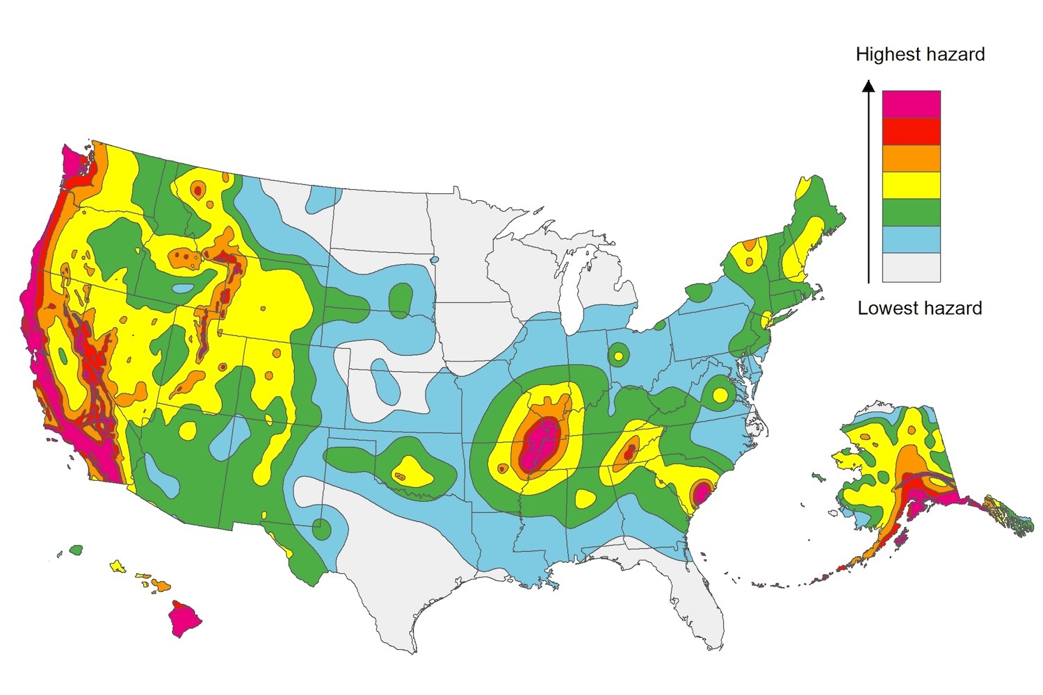
The U.S. Geological Service recently released an update of U.S. National Seismic Hazard Maps that reflect the latest analysis of where future earthquakes will occur, how frequently they may occur, and their strength.
While all states have some potential for earthquakes, 42 of the 50 states have a reasonable chance of experiencing damaging ground shaking from an earthquake in the next 50 years. Sixteen states have a relatively high likelihood of experiencing damaging ground shaking. These states have historically experienced earthquakes with a magnitude 6 or greater. The hazard is especially high along the west coast, intermountain west, and in several active regions elsewhere such as near New Madrid, Mo., and near Charleston, S.C.
The eastern U.S. has the potential for larger and more damaging earthquakes than considered in previous maps and assessments. This finding is due to what scientists learned following the magnitude 5.8 earthquakes that struck Virginia in 2011. It was among the largest earthquakes to occur along the east coast in the last century, and indicated that even larger events in the region are possible.
The maps are used in risk analyses calculated using factors such as population levels, building exposure, and building construction practices. These assessments are used for establishing building codes, in the analysis of seismic risk for key structures, and in determining insurance rates. They can also aid emergency preparedness plans, and private property decisions such as re-evaluating one’s real estate and making it more resilient.
(http://www.usgs.gov/blogs/features/usgs_top_story/new-insight-on-the-nations-earthquake-hazards/)
Related Stories
Regulations | Aug 5, 2016
Stop-work orders in New York City up sharply this year
The orders come after a rise in the number of deadly accidents that have occurred in the past few years.
Sustainability | Aug 4, 2016
S.F. Bay Area voters approve first-of-its-kind tax to fight impact of climate change
The funds from the tax will be used to restore wetlands
Concrete | Aug 2, 2016
Concrete Association builds case against cross-laminated timber
The campaign asserts that not enough is known about CLT in construction
Seismic Design | Jul 28, 2016
Risk of man-made earthquakes now factor in seismic hazard analysis
Significant risk increases seen in some areas of the U.S.
Resiliency | Jul 27, 2016
New York’s resilience plans not taking long-term view, critics charge
Continued waterfront development may be regretted later this century.
Green Specifications | Jul 26, 2016
New Miami Beach law requires LEED certification on projects larger than 7,000 sf
LEED Silver the prescribed standard on buildings larger than 50,000 sf.
Energy | Jul 25, 2016
Michigan law provides local governments with flexible energy conservation financing
Allows cities to fund projects without adding debt.
Contractors | Jul 15, 2016
Trade unions, contractors call for maximum penalty in construction worker death case
‘Sick and tired’ of lawbreaking contractors defining public perception.
Multifamily Housing | Jul 14, 2016
Portland, Ore., City Council approves construction excise tax for affordable housing
Expected to raise $8 million annually on commercial and residential projects.
Drones | Jul 13, 2016
FAA issues final rule on commercial use of drones
The rule covers commercial uses for drones that weigh less than 55 pounds, and it takes effect Aug. 29.


