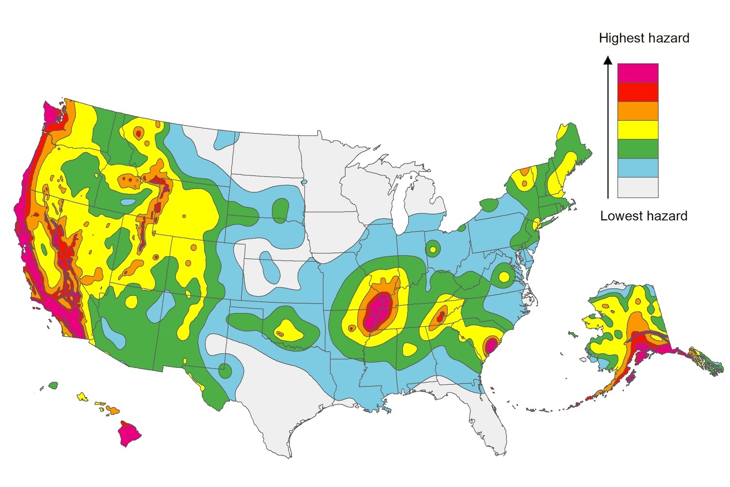
The U.S. Geological Service recently released an update of U.S. National Seismic Hazard Maps that reflect the latest analysis of where future earthquakes will occur, how frequently they may occur, and their strength.
While all states have some potential for earthquakes, 42 of the 50 states have a reasonable chance of experiencing damaging ground shaking from an earthquake in the next 50 years. Sixteen states have a relatively high likelihood of experiencing damaging ground shaking. These states have historically experienced earthquakes with a magnitude 6 or greater. The hazard is especially high along the west coast, intermountain west, and in several active regions elsewhere such as near New Madrid, Mo., and near Charleston, S.C.
The eastern U.S. has the potential for larger and more damaging earthquakes than considered in previous maps and assessments. This finding is due to what scientists learned following the magnitude 5.8 earthquakes that struck Virginia in 2011. It was among the largest earthquakes to occur along the east coast in the last century, and indicated that even larger events in the region are possible.
The maps are used in risk analyses calculated using factors such as population levels, building exposure, and building construction practices. These assessments are used for establishing building codes, in the analysis of seismic risk for key structures, and in determining insurance rates. They can also aid emergency preparedness plans, and private property decisions such as re-evaluating one’s real estate and making it more resilient.
(http://www.usgs.gov/blogs/features/usgs_top_story/new-insight-on-the-nations-earthquake-hazards/)
Related Stories
Codes and Standards | Mar 21, 2016
GRESB launches Health and Well-being Module for real estate industry
Optional supplement to environmental, social, and governance assessment.
Codes and Standards | Mar 4, 2016
U.S. Supreme Court lets San Jose affordable housing law stand
Law attempts to alleviate Silicon Valley’s high housing costs.
Codes and Standards | Mar 2, 2016
WELL standard offers multiple benefits for owners, says real estate executive
Could be a recruiting tool for occupant companies.
Cultural Facilities | Mar 1, 2016
China bans ‘weird’ public architecture, gated communities
Directs designers of public buildings to focus on functionality.
Energy Efficiency | Feb 23, 2016
Economists, energy efficiency practitioners need to work together for better cost/benefit studies
Flawed energy efficiency research yields misleading, confusing results.
Codes and Standards | Feb 16, 2016
New York City implements new crane safety plan following deadly accident
The plan includes restrictions on crawler cranes during windy conditions.
Resiliency | Feb 16, 2016
Obama establishes federal earthquake risk management standard
The standard requires federal agencies to use earthquake-resistant design provisions in current building codes.
Codes and Standards | Feb 12, 2016
ISO releases national assessment and state-by-state building codes evaluation
Report covers 87% of U.S. population.
Codes and Standards | Feb 12, 2016
Huge fraud case involving alleged engineering impostors uncovered in California
Hundreds of buildings may have to be demolished.
Codes and Standards | Feb 11, 2016
New York governor makes emergency design-build authorization
The declaration was issued in response to Winter Storm Jonas which dumped over 18 inches of snow in parts of the state.


