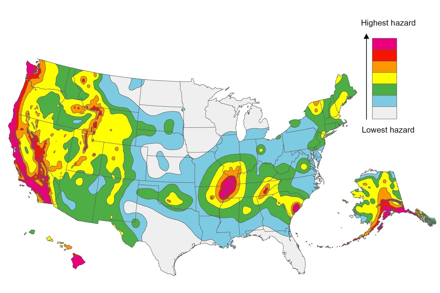
The U.S. Geological Service recently released an update of U.S. National Seismic Hazard Maps that reflect the latest analysis of where future earthquakes will occur, how frequently they may occur, and their strength.
While all states have some potential for earthquakes, 42 of the 50 states have a reasonable chance of experiencing damaging ground shaking from an earthquake in the next 50 years. Sixteen states have a relatively high likelihood of experiencing damaging ground shaking. These states have historically experienced earthquakes with a magnitude 6 or greater. The hazard is especially high along the west coast, intermountain west, and in several active regions elsewhere such as near New Madrid, Mo., and near Charleston, S.C.
The eastern U.S. has the potential for larger and more damaging earthquakes than considered in previous maps and assessments. This finding is due to what scientists learned following the magnitude 5.8 earthquakes that struck Virginia in 2011. It was among the largest earthquakes to occur along the east coast in the last century, and indicated that even larger events in the region are possible.
The maps are used in risk analyses calculated using factors such as population levels, building exposure, and building construction practices. These assessments are used for establishing building codes, in the analysis of seismic risk for key structures, and in determining insurance rates. They can also aid emergency preparedness plans, and private property decisions such as re-evaluating one’s real estate and making it more resilient.
(http://www.usgs.gov/blogs/features/usgs_top_story/new-insight-on-the-nations-earthquake-hazards/)
Related Stories
Codes and Standards | May 31, 2019
Pankow Foundation releases report, tools for embodied carbon impacts
Focus is on MEP and tenant improvements.
Codes and Standards | May 24, 2019
USGBC receives funding for LEED for Cities and Communities Program
Bank of America provides $500,000 grant to certify 15 U.S. cities.
Codes and Standards | May 24, 2019
AIA updates Interiors Contract Documents
Six revised documents available for interior construction projects.
Codes and Standards | May 23, 2019
Northern California casino offers a template for resilient microgrids
Solar power with batteries and backup generators provide weeks of self-reliance.
Codes and Standards | May 23, 2019
Austin creates innovative plan to boost affordable housing
Approach includes loosened zoning, incentives for higher density in lower-cost and mixed-income developments.
Codes and Standards | May 20, 2019
Effort launched to develop better process for zero-carbon retrofits in multifamily sector
Rocky Mountain Institute, Dept. of Energy, California Energy Commission join forces.
Codes and Standards | May 20, 2019
Property lenders shouldn’t invest for 30 years in most of Florida, expert warns
Climate ignorance driving some ‘insane’ deals.
Codes and Standards | May 17, 2019
NIMBYism is the biggest multifamily construction barrier
National Apartment Assn. report assesses reasons for difficulty in creating more apartments.
Codes and Standards | May 17, 2019
Dept. of Energy to award up to $33.5 million for advanced construction R&D
Focus is on techniques to reduce energy bills.
Codes and Standards | May 16, 2019
Mixed reviews on targeted tax break for San Francisco neighborhood
“Twitter tax break” may have worsened some of the area’s problems.


