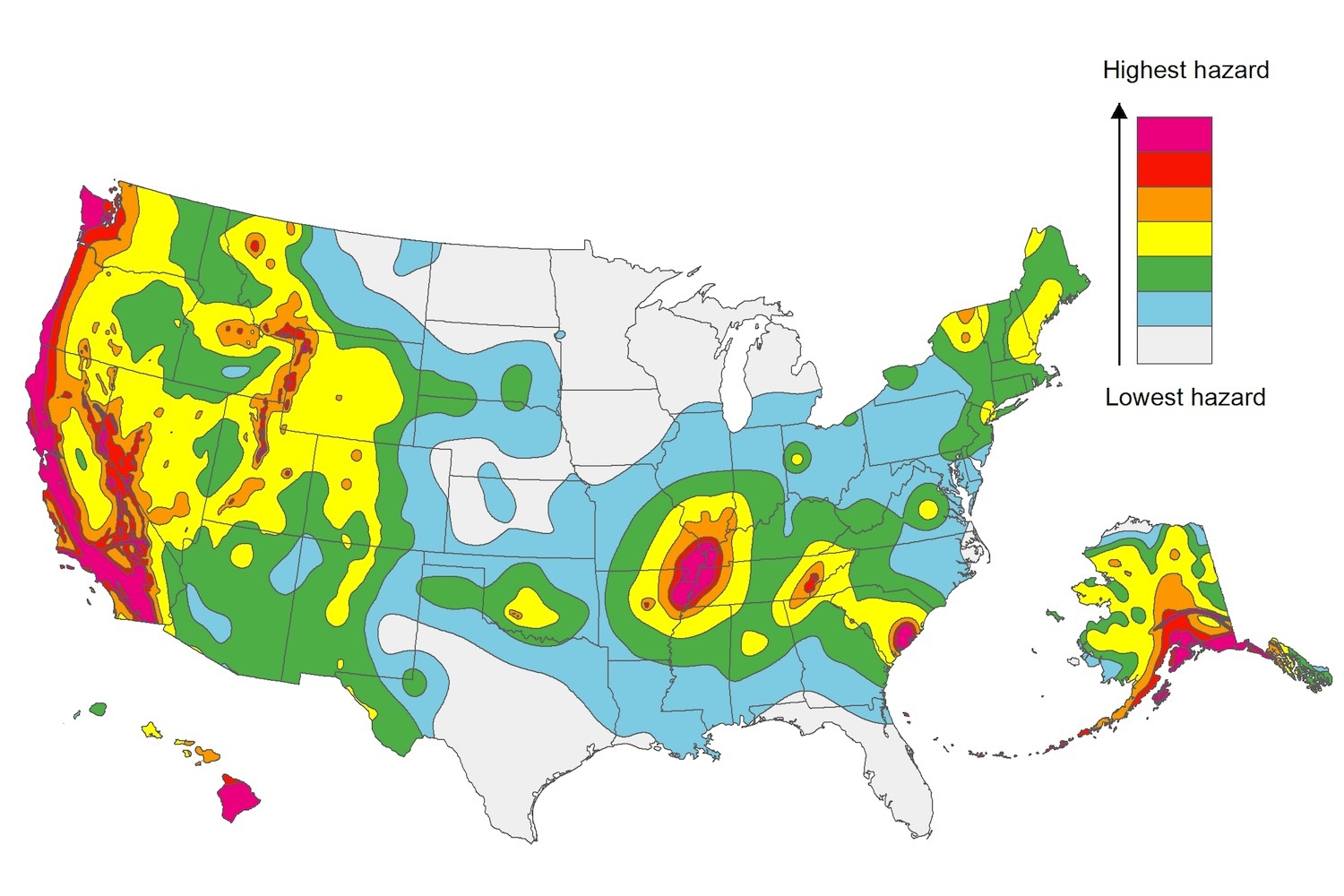
The U.S. Geological Service recently released an update of U.S. National Seismic Hazard Maps that reflect the latest analysis of where future earthquakes will occur, how frequently they may occur, and their strength.
While all states have some potential for earthquakes, 42 of the 50 states have a reasonable chance of experiencing damaging ground shaking from an earthquake in the next 50 years. Sixteen states have a relatively high likelihood of experiencing damaging ground shaking. These states have historically experienced earthquakes with a magnitude 6 or greater. The hazard is especially high along the west coast, intermountain west, and in several active regions elsewhere such as near New Madrid, Mo., and near Charleston, S.C.
The eastern U.S. has the potential for larger and more damaging earthquakes than considered in previous maps and assessments. This finding is due to what scientists learned following the magnitude 5.8 earthquakes that struck Virginia in 2011. It was among the largest earthquakes to occur along the east coast in the last century, and indicated that even larger events in the region are possible.
The maps are used in risk analyses calculated using factors such as population levels, building exposure, and building construction practices. These assessments are used for establishing building codes, in the analysis of seismic risk for key structures, and in determining insurance rates. They can also aid emergency preparedness plans, and private property decisions such as re-evaluating one’s real estate and making it more resilient.
(http://www.usgs.gov/blogs/features/usgs_top_story/new-insight-on-the-nations-earthquake-hazards/)
Related Stories
Codes and Standards | Aug 7, 2019
Illinois law makes all single-occupancy restrooms gender-neutral
All must comply by January 1.
Codes and Standards | Aug 6, 2019
New technology, aligning training with local trends among keys to workforce development
Construction industry must also invest in training, recruiting high school students.
Codes and Standards | Aug 1, 2019
Planners, city official rethink parking requirements on new projects
Reducing number of parking spots frees up land for ‘more purposeful’ uses.
Codes and Standards | Jul 31, 2019
USGBC-LA chooses first ‘Net Zero Accelerator’ technologies
Wide range of solutions address numerous environmental challenges.
Codes and Standards | Jul 30, 2019
Solar brokerage will provide financing for small/medium businesses
First to fund solar for smaller-scale commercial operations.
Codes and Standards | Jul 29, 2019
ASCE group unveils structural safety database
Confidential reporting on structural failures, near misses, and other incidents.
Codes and Standards | Jul 26, 2019
Floating landscape infrastructure wins top ASCE innovation prize
Climate resiliency a key theme of entrants.
Codes and Standards | Jul 24, 2019
New York making slow progress on resiliency seven years after Hurricane Sandy
Property owners face many challenges; coastal defense project plans are complex and need more time to plan.
Codes and Standards | Jul 23, 2019
Berkeley, Calif. passes nation’s first ordinance to make new buildings all-electric
No gas hook-ups will be allowed in new houses, apartments, and commercial buildings.
Codes and Standards | Jul 22, 2019
San Francisco office building is city’s first structure certified by BREEAM USA for existing buildings
The Landmark @ One Market is one of San Francisco’s most architecturally distinctive buildings.


