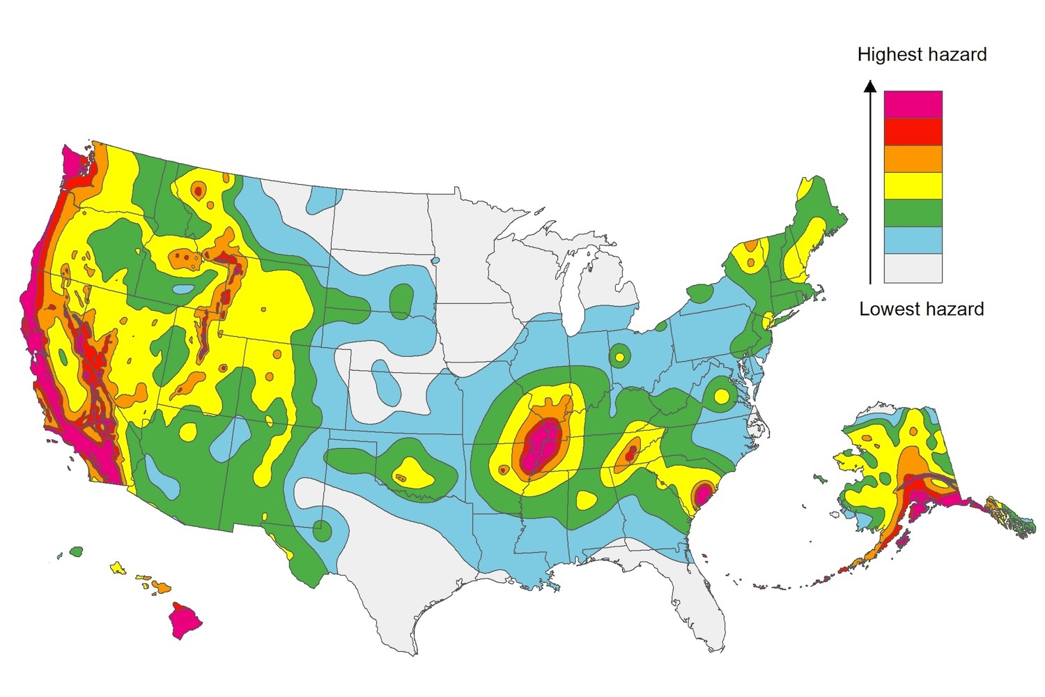
The U.S. Geological Service recently released an update of U.S. National Seismic Hazard Maps that reflect the latest analysis of where future earthquakes will occur, how frequently they may occur, and their strength.
While all states have some potential for earthquakes, 42 of the 50 states have a reasonable chance of experiencing damaging ground shaking from an earthquake in the next 50 years. Sixteen states have a relatively high likelihood of experiencing damaging ground shaking. These states have historically experienced earthquakes with a magnitude 6 or greater. The hazard is especially high along the west coast, intermountain west, and in several active regions elsewhere such as near New Madrid, Mo., and near Charleston, S.C.
The eastern U.S. has the potential for larger and more damaging earthquakes than considered in previous maps and assessments. This finding is due to what scientists learned following the magnitude 5.8 earthquakes that struck Virginia in 2011. It was among the largest earthquakes to occur along the east coast in the last century, and indicated that even larger events in the region are possible.
The maps are used in risk analyses calculated using factors such as population levels, building exposure, and building construction practices. These assessments are used for establishing building codes, in the analysis of seismic risk for key structures, and in determining insurance rates. They can also aid emergency preparedness plans, and private property decisions such as re-evaluating one’s real estate and making it more resilient.
(http://www.usgs.gov/blogs/features/usgs_top_story/new-insight-on-the-nations-earthquake-hazards/)
Related Stories
Codes and Standards | Sep 30, 2021
U.S. has a deficit of 5 million homes
Builders unable to keep pace with demand.
Codes and Standards | Sep 29, 2021
Mass Timber group study will compare structural round timber to glulam products and steel
Will compare costs, capabilities, and carbon impacts of structural materials.
Codes and Standards | Sep 28, 2021
Massachusetts creates Commission on Clean Heat
First-of-its kind body to set targets for buildings to reduce emissions from heating fuels.
Codes and Standards | Sep 27, 2021
Commercial real estate industry faces SEC climate disclosure regulations
Risks associated with climate change would have to be revealed.
Codes and Standards | Sep 22, 2021
Group proposes Carbon Use Intensity metric for new buildings
Plan would track embedded carbon on projects.
Codes and Standards | Sep 22, 2021
Illinois’s sweeping climate bill includes statewide stretch code, building electrification measures
Aims for zero-emissions power sector by 2045.
Codes and Standards | Sep 22, 2021
Cities need to step up flood mitigation efforts to save lives
Recent storms highlight climate change dangers.
Codes and Standards | Sep 21, 2021
Steps to improve ventilation for Covid can combat colds and flu
New look at airborne disease spread shows time viruses linger in air may have been underestimated.
Codes and Standards | Sep 15, 2021
USGBC will change leaders, conduct strategic review
Aims to ensure organization is ‘well positioned to scale its work in the post-pandemic world’.
Codes and Standards | Sep 15, 2021
LEED-certified offices earn higher rents than non-sustainable properties
Are also more resilient to dips in real estate market.


