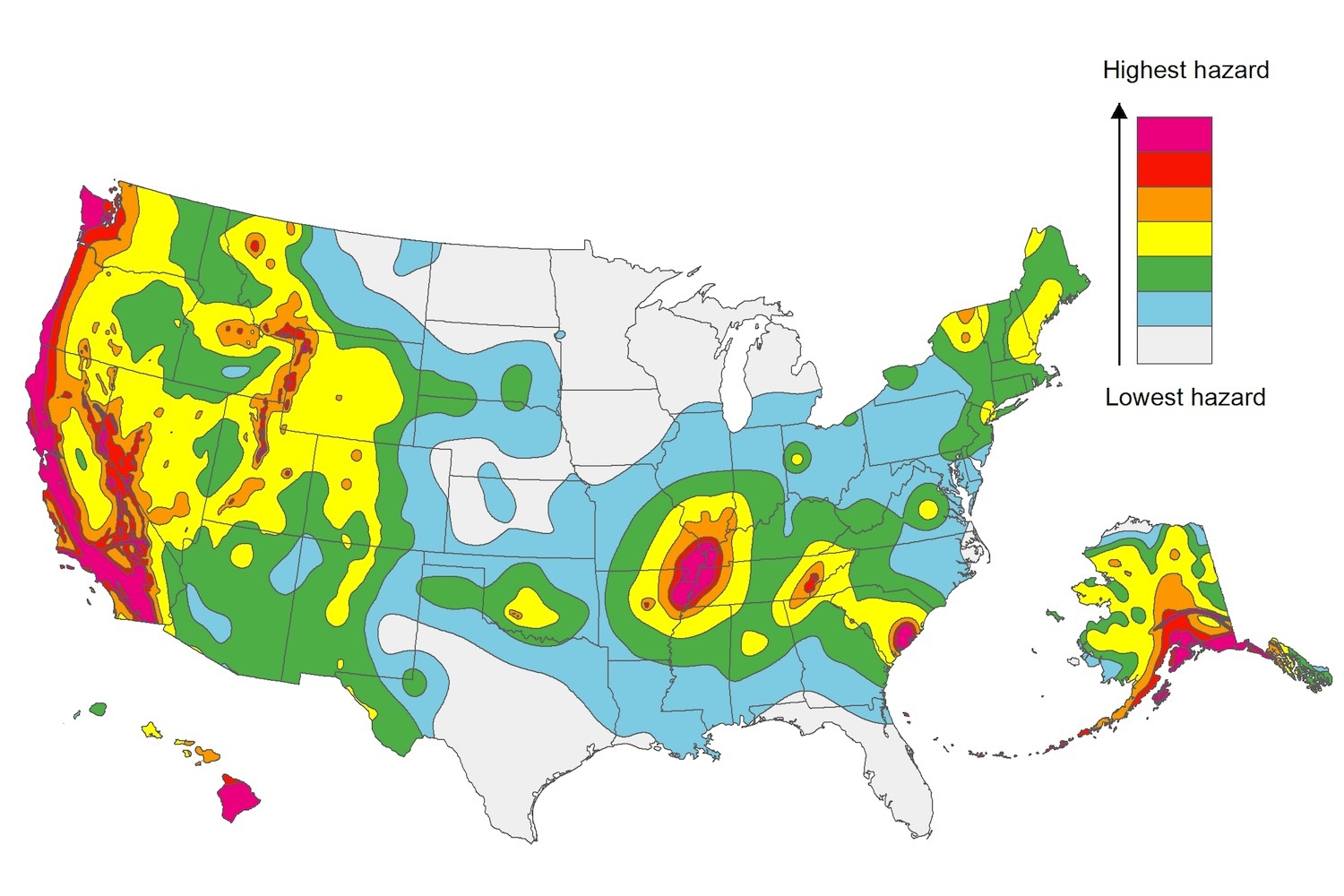
The U.S. Geological Service recently released an update of U.S. National Seismic Hazard Maps that reflect the latest analysis of where future earthquakes will occur, how frequently they may occur, and their strength.
While all states have some potential for earthquakes, 42 of the 50 states have a reasonable chance of experiencing damaging ground shaking from an earthquake in the next 50 years. Sixteen states have a relatively high likelihood of experiencing damaging ground shaking. These states have historically experienced earthquakes with a magnitude 6 or greater. The hazard is especially high along the west coast, intermountain west, and in several active regions elsewhere such as near New Madrid, Mo., and near Charleston, S.C.
The eastern U.S. has the potential for larger and more damaging earthquakes than considered in previous maps and assessments. This finding is due to what scientists learned following the magnitude 5.8 earthquakes that struck Virginia in 2011. It was among the largest earthquakes to occur along the east coast in the last century, and indicated that even larger events in the region are possible.
The maps are used in risk analyses calculated using factors such as population levels, building exposure, and building construction practices. These assessments are used for establishing building codes, in the analysis of seismic risk for key structures, and in determining insurance rates. They can also aid emergency preparedness plans, and private property decisions such as re-evaluating one’s real estate and making it more resilient.
(http://www.usgs.gov/blogs/features/usgs_top_story/new-insight-on-the-nations-earthquake-hazards/)
Related Stories
Codes and Standards | Aug 3, 2021
Dept. of Energy releases initial version of the Spawn of EnergyPlus software
Targets new use cases in advanced controls, district systems, and grid integration.
Codes and Standards | Aug 2, 2021
Several U.S. cities among most expensive places to build in the world
San Francisco, New York, and Boston head the domestic list.
Codes and Standards | Jul 28, 2021
American Concrete Institute creates new director of innovative concrete technology post
Aim is to attract emerging technologies for development.
Codes and Standards | Jul 28, 2021
Higher ed faces infrastructure backlog of $112.3 billion
Study recommends integrated strategic planning for best results.
Codes and Standards | Jul 27, 2021
Add a wobbly moon to flooding risk factors
Earth satellite’s orbit variations will lead to sunny-day flooding in the mid-2030s.
Codes and Standards | Jul 26, 2021
Revamping of Florida building codes on the table after condo collapse
Tragedy could prompt upgrades like post-Hurricane Andrew effort.
Codes and Standards | Jul 21, 2021
Proposal to give Calif. hospitals more time for earthquake retrofits stirs controversy
State hospital association says 2030 deadline should be extended.
Codes and Standards | Jul 20, 2021
New York, New Jersey legislatures may revamp bidding rules to promote low-carbon concrete
Contractors would have to certify that their concrete is in compliance.
Codes and Standards | Jul 19, 2021
Lack of information on carbon emissions challenges construction industry
Reports recommends whole-life carbon assessments on building projects.
Codes and Standards | Jul 19, 2021
Florida condo collapse spurs increased scrutiny on inspections, regulations
Insurers demand proof of current inspections.


