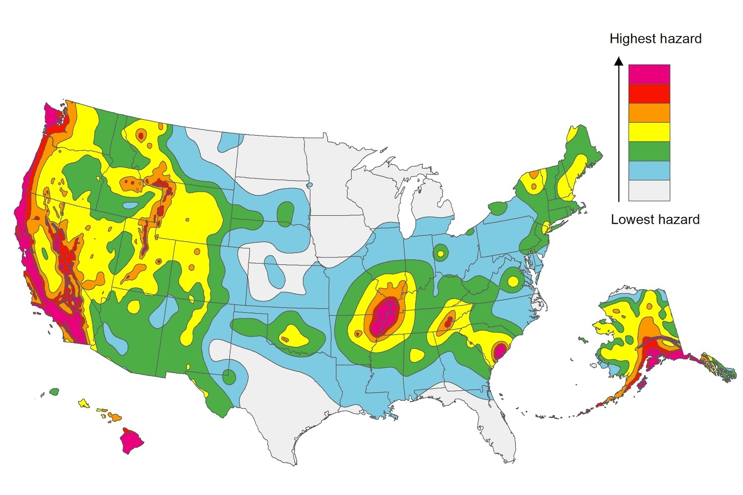
The U.S. Geological Service recently released an update of U.S. National Seismic Hazard Maps that reflect the latest analysis of where future earthquakes will occur, how frequently they may occur, and their strength.
While all states have some potential for earthquakes, 42 of the 50 states have a reasonable chance of experiencing damaging ground shaking from an earthquake in the next 50 years. Sixteen states have a relatively high likelihood of experiencing damaging ground shaking. These states have historically experienced earthquakes with a magnitude 6 or greater. The hazard is especially high along the west coast, intermountain west, and in several active regions elsewhere such as near New Madrid, Mo., and near Charleston, S.C.
The eastern U.S. has the potential for larger and more damaging earthquakes than considered in previous maps and assessments. This finding is due to what scientists learned following the magnitude 5.8 earthquakes that struck Virginia in 2011. It was among the largest earthquakes to occur along the east coast in the last century, and indicated that even larger events in the region are possible.
The maps are used in risk analyses calculated using factors such as population levels, building exposure, and building construction practices. These assessments are used for establishing building codes, in the analysis of seismic risk for key structures, and in determining insurance rates. They can also aid emergency preparedness plans, and private property decisions such as re-evaluating one’s real estate and making it more resilient.
(http://www.usgs.gov/blogs/features/usgs_top_story/new-insight-on-the-nations-earthquake-hazards/)
Related Stories
Codes and Standards | Nov 3, 2021
Fact sheets offer strategies to improve indoor air quality in schools
Center for Green Schools at USGBC document for people without a technical background.
Codes and Standards | Nov 2, 2021
Rapid acceleration of affordable housing development expected over next five years
Federal government programs will spur construction.
Codes and Standards | Nov 1, 2021
New bird-friendly technical design guide released
National Glass Assn. document offers design and installation best practices for glazing.
Codes and Standards | Nov 1, 2021
World’s first chief heat officer tackles how to protect Miamians from extreme heat
Focus on chronic exposure for outdoor workers and for those that can’t afford AC.
Codes and Standards | Oct 28, 2021
Design competition launched to show role of mass timber in decarbonization
Forest Service and Softwood Lumber Board will award $2 million in grants to winning teams.
Codes and Standards | Oct 27, 2021
Texas reforms series of contractor laws
Measures seen as making it easier to do business in the state.
Codes and Standards | Oct 26, 2021
Drownings during Hurricane Ida point out FEMA flood map flaws
Eleven people drowned in New York City in areas marked as low risk.
Codes and Standards | Oct 26, 2021
Dept. of Energy’s REScheck tool updated for the 2021 International Energy Conservation Code
Previous version incorporated 2018 code.
Codes and Standards | Oct 20, 2021
New York City passes overhaul of construction codes
Over 600 major changes along with thousands of smaller updates slated for 2022.
Codes and Standards | Oct 20, 2021
One-quarter of U.S. critical infrastructure at risk of failure due to flooding
Police and fire stations, hospitals, airports, and wastewater treatment facilities face threat.


