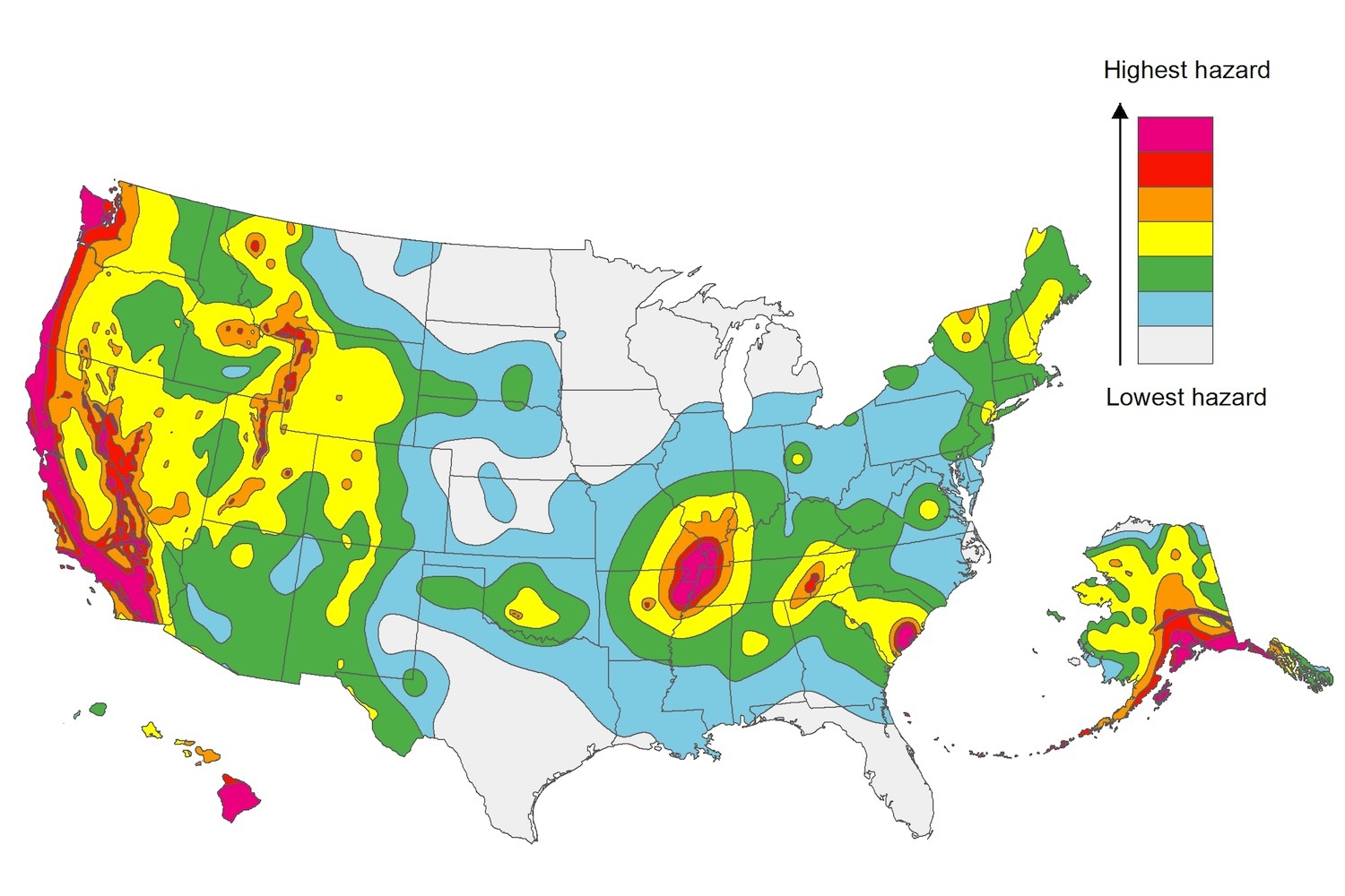
The U.S. Geological Service recently released an update of U.S. National Seismic Hazard Maps that reflect the latest analysis of where future earthquakes will occur, how frequently they may occur, and their strength.
While all states have some potential for earthquakes, 42 of the 50 states have a reasonable chance of experiencing damaging ground shaking from an earthquake in the next 50 years. Sixteen states have a relatively high likelihood of experiencing damaging ground shaking. These states have historically experienced earthquakes with a magnitude 6 or greater. The hazard is especially high along the west coast, intermountain west, and in several active regions elsewhere such as near New Madrid, Mo., and near Charleston, S.C.
The eastern U.S. has the potential for larger and more damaging earthquakes than considered in previous maps and assessments. This finding is due to what scientists learned following the magnitude 5.8 earthquakes that struck Virginia in 2011. It was among the largest earthquakes to occur along the east coast in the last century, and indicated that even larger events in the region are possible.
The maps are used in risk analyses calculated using factors such as population levels, building exposure, and building construction practices. These assessments are used for establishing building codes, in the analysis of seismic risk for key structures, and in determining insurance rates. They can also aid emergency preparedness plans, and private property decisions such as re-evaluating one’s real estate and making it more resilient.
(http://www.usgs.gov/blogs/features/usgs_top_story/new-insight-on-the-nations-earthquake-hazards/)
Related Stories
| Nov 20, 2013
Boston officials grapple with impact of new FEMA flood maps
New federal maps for Boston significantly expand the number of homes and businesses in areas considered at high risk of flooding, a change that could force thousands of property owners to purchase expensive insurance and complicate redevelopment along the city’s waterfront.
| Nov 20, 2013
How LEED and Green Globes stack up
An analysis of the strengths and weaknesses of the Green Globes rating system and LEED standards puts LEED ahead, but doesn’t discount the merits of Green Globes.
| Nov 14, 2013
First LEED v4 certified project garnered by Beijing furniture showroom
Haworth’s showroom in Beijing’s Parkview Green building has been recognized as the world’s first certified LEED project under the USGBC’s new LEED version 4 beta program.
| Nov 14, 2013
OSHA proposes requirement for large firms to disclose workplace injuries
A proposal from the Occupational Safety and Health Administration would require companies with more than 250 employees to disclose workplace injury and illness reports online.
| Nov 14, 2013
GSA asks for input to help study energy-efficient technologies on its buildings
The General Services Administration has posted a request online, asking those in industry, academia and nonprofits for information on green building technologies.
| Nov 14, 2013
Document on gypsum boards sets stage for preparing Environmental Product Declaration
The Gypsum Association has completed the development of a product category rules (PCR) document for North American gypsum boards.
| Nov 14, 2013
ISO, FLASH team up to promote stronger building codes
ISO has joined the national nonprofit Federal Alliance for Safe Homes (FLASH) to encourage communities to build disaster-resistant buildings that can withstand hurricanes, tornadoes, earthquakes, and other catastrophic events.
| Nov 6, 2013
Cost to small businesses from silica rule is raised by progressive group
The silica-dust rule from the Occupational Safety and Health Administration could put small businesses at a disadvantage on the cost of complying with the mandate, according to the Center for Progressive Reform.
| Nov 6, 2013
Uneven snow load concern prompts structural study of Minnesota college auditorium roof
The roof of the Memorial Auditorium of Concordia College in Minnesota will undergo a complete structural analysis because it was built to 1946 codes and may not be able to accommodate uneven snow loads.
| Nov 6, 2013
Dallas’s goal of carbon neutrality by 2030 advances with second phase of green codes
Dallas stands out as one of the few large cities that is enforcing a green building code, with the city aiming to be carbon neutral by 2030.


