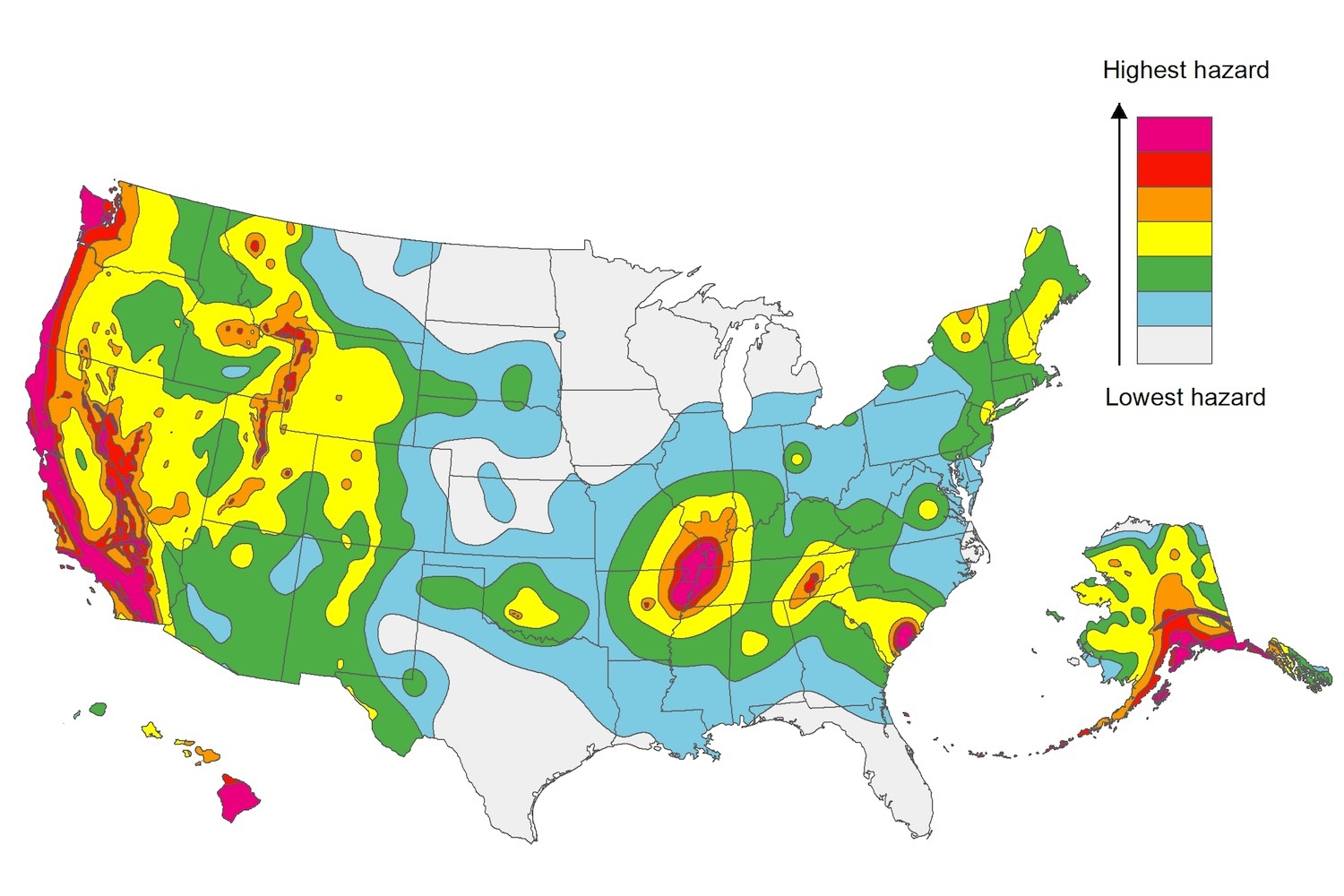
The U.S. Geological Service recently released an update of U.S. National Seismic Hazard Maps that reflect the latest analysis of where future earthquakes will occur, how frequently they may occur, and their strength.
While all states have some potential for earthquakes, 42 of the 50 states have a reasonable chance of experiencing damaging ground shaking from an earthquake in the next 50 years. Sixteen states have a relatively high likelihood of experiencing damaging ground shaking. These states have historically experienced earthquakes with a magnitude 6 or greater. The hazard is especially high along the west coast, intermountain west, and in several active regions elsewhere such as near New Madrid, Mo., and near Charleston, S.C.
The eastern U.S. has the potential for larger and more damaging earthquakes than considered in previous maps and assessments. This finding is due to what scientists learned following the magnitude 5.8 earthquakes that struck Virginia in 2011. It was among the largest earthquakes to occur along the east coast in the last century, and indicated that even larger events in the region are possible.
The maps are used in risk analyses calculated using factors such as population levels, building exposure, and building construction practices. These assessments are used for establishing building codes, in the analysis of seismic risk for key structures, and in determining insurance rates. They can also aid emergency preparedness plans, and private property decisions such as re-evaluating one’s real estate and making it more resilient.
(http://www.usgs.gov/blogs/features/usgs_top_story/new-insight-on-the-nations-earthquake-hazards/)
Related Stories
Codes and Standards | Mar 11, 2021
Los Angeles commits to carbon-free city buildings
City will take into account embedded carbon when contracting to buy construction products.
Codes and Standards | Mar 10, 2021
‘Smart retrofitting’ will be crucial to net zero aspirations
AI, analytical software, Internet of Things are keys to decarbonization of built environment.
Codes and Standards | Mar 9, 2021
Salt Lake City is first jurisdiction to adopt new standards for off-site construction
Code Council and Modular Building Institute developing standards and compliance protocols.
Codes and Standards | Mar 8, 2021
Hyperlocal zoning could spur more affordable housing construction
Letting blocks and streets pass their own rules could have impact.
Codes and Standards | Mar 5, 2021
Biden builds on Trump’s “Buy American” order
New administration extends preferences for domestic construction materials.
Codes and Standards | Mar 4, 2021
Biden administration overturns Trump’s federal building design mandate
Previous order promoted classical and “traditional” architecture above others.
Codes and Standards | Mar 3, 2021
Texas freeze raises questions about risks of electrifying buildings
Gas stoves helped residents cook, boil water when power went out.
Codes and Standards | Mar 2, 2021
New Seattle building code eliminates fossil fuels for most space and water heating
Also increases on-site solar photovoltaics, reduces envelope heat loss, air leakage, and interior lighting power allowances.
Codes and Standards | Feb 25, 2021
It’s not just lumber—roofing material prices are also on the rise
Lower demand for petroleum products means less asphalt production.
Codes and Standards | Feb 23, 2021
USGBC offers education on LEED Safety First pilot credits
Four courses address COVID-19.


