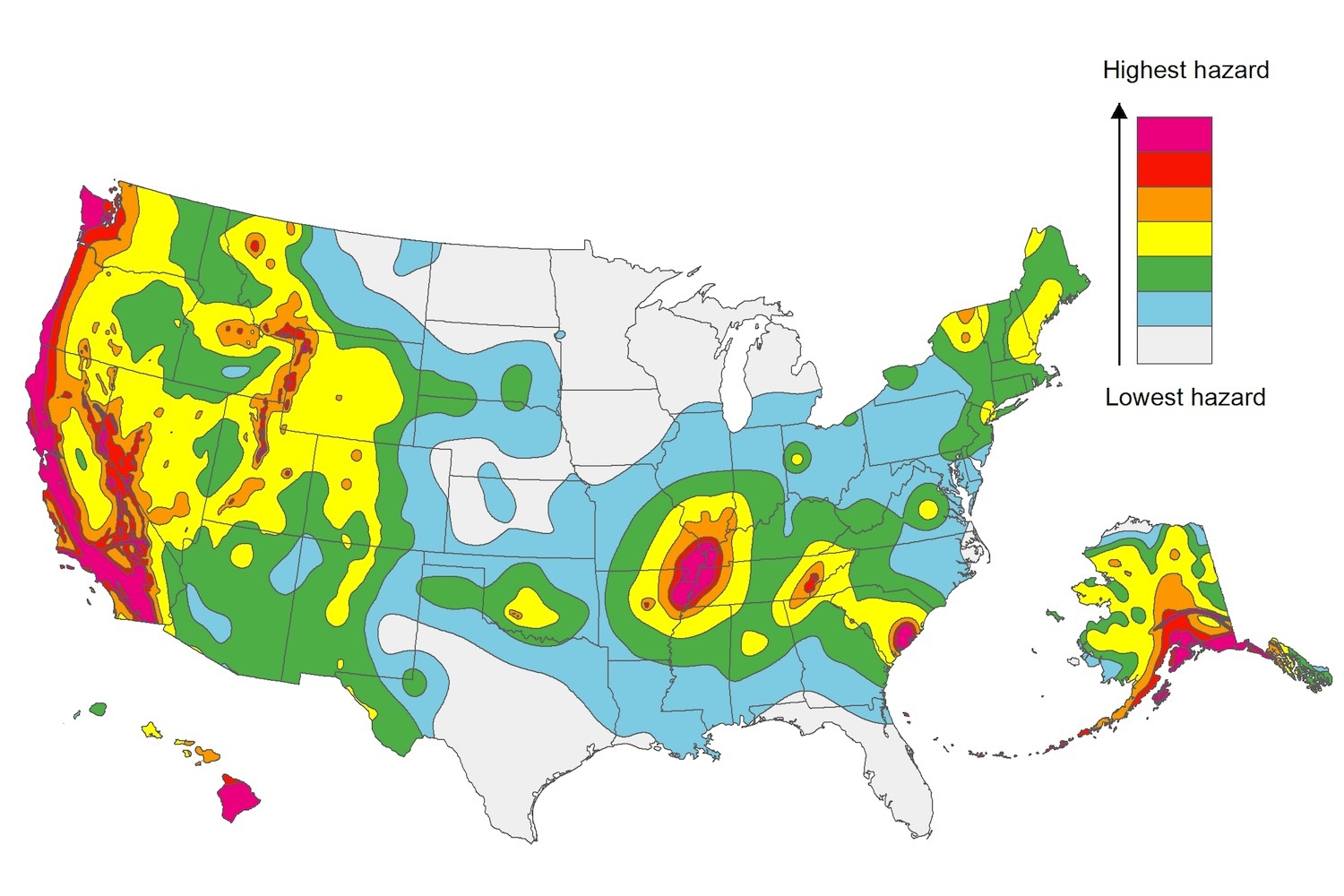
The U.S. Geological Service recently released an update of U.S. National Seismic Hazard Maps that reflect the latest analysis of where future earthquakes will occur, how frequently they may occur, and their strength.
While all states have some potential for earthquakes, 42 of the 50 states have a reasonable chance of experiencing damaging ground shaking from an earthquake in the next 50 years. Sixteen states have a relatively high likelihood of experiencing damaging ground shaking. These states have historically experienced earthquakes with a magnitude 6 or greater. The hazard is especially high along the west coast, intermountain west, and in several active regions elsewhere such as near New Madrid, Mo., and near Charleston, S.C.
The eastern U.S. has the potential for larger and more damaging earthquakes than considered in previous maps and assessments. This finding is due to what scientists learned following the magnitude 5.8 earthquakes that struck Virginia in 2011. It was among the largest earthquakes to occur along the east coast in the last century, and indicated that even larger events in the region are possible.
The maps are used in risk analyses calculated using factors such as population levels, building exposure, and building construction practices. These assessments are used for establishing building codes, in the analysis of seismic risk for key structures, and in determining insurance rates. They can also aid emergency preparedness plans, and private property decisions such as re-evaluating one’s real estate and making it more resilient.
(http://www.usgs.gov/blogs/features/usgs_top_story/new-insight-on-the-nations-earthquake-hazards/)
Related Stories
Codes and Standards | Jan 10, 2018
Sliding-scale proposal for civil damages resulting from construction fatalities, injuries draws ire of trades
New York City Council proposal puts limits on penalties for safety violations leading to death, serious injury.
Codes and Standards | Jan 9, 2018
Federal appeals court orders EPA to revise lead standard within a year
Current exposure levels for lead in paint and dust have been in place for 17 years.
Codes and Standards | Jan 5, 2018
Building code officials should vet building product evaluation methods
Evaluation service providers should be properly accredited.
Codes and Standards | Jan 4, 2018
U.S. military needs to do more to address climate change risk for facility design
GAO report cites hundreds of overseas facilities in peril.
Codes and Standards | Jan 3, 2018
China Construction America faces billions of dollars in liability in lawsuit
Court filing alleges massive fraud and breaches of contract in Baha Mar Resort Project.
Codes and Standards | Jan 2, 2018
Smart building tech can reap utility savings of 8% to 18% in commercial buildings
Potential for increased deployment of smart building technology is great beyond early adopters.
Reconstruction & Renovation | Dec 21, 2017
Interactive map includes detailed information on historic New York City buildings
The New York City Landmarks Preservation Commission launched a new, enhanced version of its interactive map, Discover NYC Landmarks.
Codes and Standards | Dec 20, 2017
Moody’s says cities may face credit downgrades if they don’t address climate risks
Credit ratings giant will ask what communities are doing to mitigate risk exposure.
Codes and Standards | Dec 18, 2017
Schools with optimal indoor environments boost student performance and energy efficiency
World Green Building Council report confirms that lighting, indoor air quality, thermal comfort and acoustics impact learning.
Codes and Standards | Dec 14, 2017
Mayors sign Chicago Climate Charter; will strive to meet Paris accord goals
Pledge to push for more local authority to reduce emissions.


