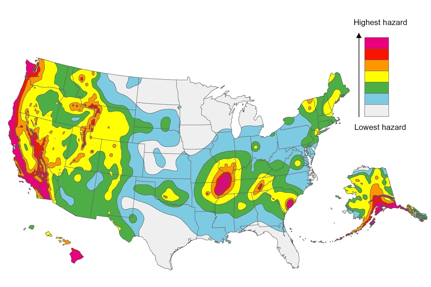
The U.S. Geological Service recently released an update of U.S. National Seismic Hazard Maps that reflect the latest analysis of where future earthquakes will occur, how frequently they may occur, and their strength.
While all states have some potential for earthquakes, 42 of the 50 states have a reasonable chance of experiencing damaging ground shaking from an earthquake in the next 50 years. Sixteen states have a relatively high likelihood of experiencing damaging ground shaking. These states have historically experienced earthquakes with a magnitude 6 or greater. The hazard is especially high along the west coast, intermountain west, and in several active regions elsewhere such as near New Madrid, Mo., and near Charleston, S.C.
The eastern U.S. has the potential for larger and more damaging earthquakes than considered in previous maps and assessments. This finding is due to what scientists learned following the magnitude 5.8 earthquakes that struck Virginia in 2011. It was among the largest earthquakes to occur along the east coast in the last century, and indicated that even larger events in the region are possible.
The maps are used in risk analyses calculated using factors such as population levels, building exposure, and building construction practices. These assessments are used for establishing building codes, in the analysis of seismic risk for key structures, and in determining insurance rates. They can also aid emergency preparedness plans, and private property decisions such as re-evaluating one’s real estate and making it more resilient.
(http://www.usgs.gov/blogs/features/usgs_top_story/new-insight-on-the-nations-earthquake-hazards/)
Related Stories
Codes and Standards | Mar 26, 2018
National Roofing Contractors Assn., releases updates to its Roof Wind Designer app
Significant changes to online wind-load calculator.
Codes and Standards | Mar 22, 2018
Global construction waste to almost double by 2025
Concerns in Houston, Minnesota over environmental impacts.
Codes and Standards | Mar 21, 2018
Cape Town, South Africa’s dire water supply crisis raises concerns in the U.S.
Los Angeles, Salt Lake City, and Miami among cities at risk for water shortages.
Codes and Standards | Mar 20, 2018
Report shows how LEED certification supports net zero energy
Whole-building energy simulation, ASHRAE compliance requirement are key factors.
Codes and Standards | Mar 15, 2018
Energy efficiency measures contributing to flat demand for power
Utilities having difficulty adjusting to new business environment.
Codes and Standards | Mar 14, 2018
New parking lighting technology is paying off, Energy Dept. says
Newer products can cut energy costs by as much as 70%.
Codes and Standards | Mar 13, 2018
OSHA delays enforcement of beryllium exposure rule
The Occupational Safety and Health Administration (OSHA) voted to delay new beryllium exposure rules until May 11.
Codes and Standards | Mar 12, 2018
L.A. mayor proposes mandatory seismic retrofits for steel buildings, daycare centers, private schools
Los Angeles Mayor Eric Garcetti has proposed a seismic retrofit requirement for vulnerable steel buildings built before the 1994 Northridge earthquake.
Codes and Standards | Mar 8, 2018
Net zero commercial building trend shows strong momentum
Almost 50% more zero energy commercial buildings under construction in 2017.
Codes and Standards | Mar 7, 2018
Dept. of Energy says 2016 ANSI/ASHRAE/IES Standard 90.1 would save 8.2% of energy costs
Favorable comparison to 2013 standard for commercial buildings.


