


Thanks to researchers in the Cockrell School of Engineering at The University of Texas at Austin, unmanned aerial vehicles can soon deliver packages to a specific spot on a customer’s back porch.
According to Phys.org, the new centimeter-accurate GPS system “could transform virtual reality and mobile devices.”
Though centimeter-accurate positioning systems are already used in fields such as geology, surveying, and mapping, the devices have always been too large and costly. Now, this precision can soon be found with the help of the average mobile phone.
Todd Humphreys, Assistant Professor in the Department of Aerospace Engineering and Engineering Mechanics, worked with a student to establish a startup, Radiosense, to further develop the technology.
Phys.org reports that Humphreys and his team are “working with Samsung to develop a snap-on accessory that will tell smartphones, tablets, and virtual reality headsets their precise position and orientation.”
Related Stories

| Apr 23, 2014
Ahead of the crowd: How architects can utilize crowdsourcing for project planning
Advanced methods of data collection, applied both prior to design and after opening, are bringing a new focus to the entire planning process.

Sponsored | | Apr 17, 2014
Technology enables state transportation agency to make the leap to digital design review
Earlier this month, my colleague and I presented a session to a group of civil engineers and transportation agencies about the tech trends in the AEC space. Along with advice on how to prepare your plan for controlled collaboration, we also talked through some practical use cases. One such use case was especially interesting, as it outlined a challenge not unfamiliar to government agencies who are contemplating the leap from paper to digital processes: how to securely migrate workflows.

| Apr 10, 2014
Submit Your Project for a Bluebeam eXtreme Award!
Bluebeam is holding the second annual Bluebeam eXtreme Awards at the 2014 Bluebeam eXtreme Conference in Hollywood, Calf.

| Apr 3, 2014
Security, accountability, and cloud access: Can you really have it all?
I’ve heard countless stories of conversations between project engineers and IT professionals who can’t come to an agreement on the level of security needed to protect their data while making it more accessible—not only externally, but also internally.
| Apr 2, 2014
New Autodesk software allows visualization of more realistic bridge concepts
The Autodesk InfraWorks 360 family of offerings now includes enhanced roads and highways capabilities, better representations of graphical information, and fixed-length pipe modeling capability.

| Mar 26, 2014
Zaha Hadid's glimmering 'cultural hub of Seoul' opens with fashion, flair [slideshow]
The new space, the Dongdaemun Design Plaza, is a blend of park and cultural spaces meant for the public to enjoy.

| Mar 20, 2014
Fluor defines the future 7D deliverable without losing sight of real results today
A fascinating client story by Fluor SVP Robert Prieto reminds us that sometimes it’s the simplest details that can bring about real results today—and we shouldn’t overlook them, even as we push to change the future state of project facilitation.
| Mar 12, 2014
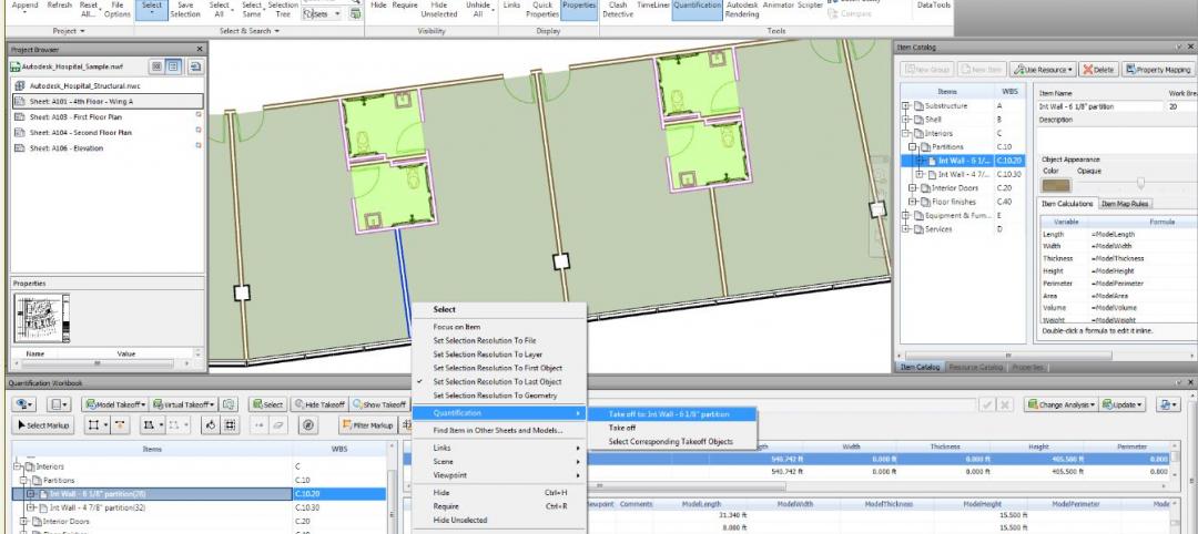
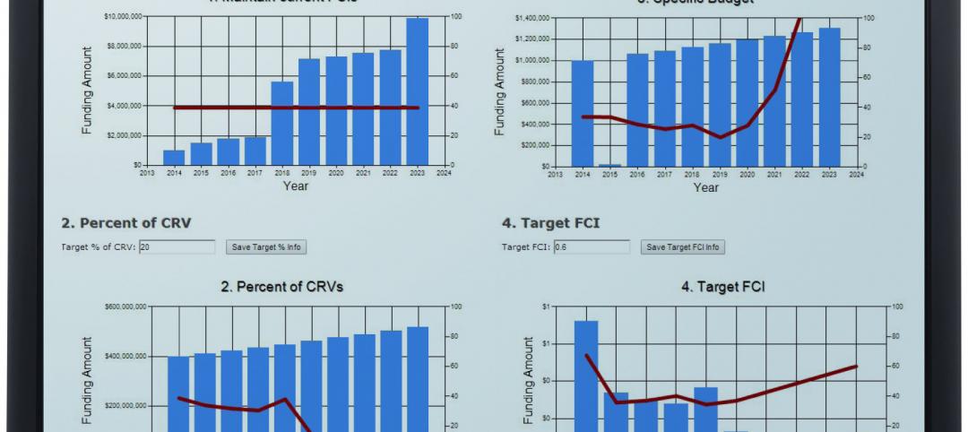
New CannonDesign database allows users to track facility assets
The new software identifies critical failures of components and systems, code and ADA-compliance issues, and systematically justifies prudent expenditures.

| Mar 10, 2014
Meet Tally – the Revit app that calculates the environmental impact of building materials
Tally provides AEC professionals with insight into how materials-related decisions made during design influence a building’s overall ecological footprint.

| Mar 10, 2014
Field tested: Caterpillar’s Cat B15 rugged smartphone
The B15 is billed by Cat as “the most progressive, durable and rugged device available on the market today.”


