Virtual site visits help control infection on project sites
By Andrew Graham, AIA, NCARB, Leo A Daly and Jason Dittrich, Director of Business Development and Marketing, Mueller Associates
COVID-19 has shut down non-essential construction projects in some areas and slowed progress in others. Where projects are considered essential, they face disruptive physical distancing requirements, schedule delays, and restrictive onsite visits.
Meanwhile, as hotels, offices, universities and municipal facilities sit mostly vacant, many building owners are eager to use this downtime to complete long overdue renovation projects. Clients, designers, and builders are asking, how can we execute a renovation with as few people on–site as possible?
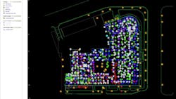
Point cloud technology offers a solution. Using data collected from a laser scan, We’ve been able to cut down in-person site visits by between 70-80 percent Point cloud data translated into a detailed BIM model allows our teams to make virtual site visits and collaborate remotely with designers of every discipline, along with our clients, to visualize, measure and plan many design elements without setting foot on site.
As long as infection control measures prohibit or limit site visits and in-person meetings, point cloud technology will be integral to promoting safety and maintaining a project’s design schedule.
The challenge of distancing
Distancing measures, while necessary for safety, have the potential to affect schedules and costs. Current guidelines require site visitors to observe six feet of distance from others at all times. When these restrictions are in place, the presence of architects and engineers on–site for field verification may be impractical.
In renovation projects, regular site visits by design team members are required to conduct field measurements, visual checks of documentation, supplemental hand sketches and photography. Multiple project team members, including architects, structural engineers, MEP engineers, fire protection engineers, audio/visual engineers, and specialty subconsultants each need different information from the physical site, presenting infection control liabilities and logistical challenges for building owners and designers.
The point cloud solution
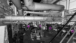
The use of point cloud data has become a regular feature of our workflow when designing renovations. While critical dimensions still need to be verified on-site (for example, relative heights of stair landings) the 3D model provides the design team with easy access to more data points than a typical site survey would yield. In situations where otherwise inaccessible spaces can be scanned – such as plenums or crawl spaces – the design team is equipped with even more data to inform design.
The best way to calculate the financial benefit of a point cloud scan is by considering the time saved with this process. For example, taking a measurement ordinarily requires time to travel to a site, check-in, be escorted, get the dimension, take a picture and travel back to the office. Compare that with the time it takes to open a program and get the dimension there. In our experience, even for a project that is nearby, that’s the difference between a two–hour site visit and a ten–minute a point-cloud check. It could easily be more extreme for projects that are further away or less accessible due to reasons of security.
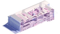
Point cloud data fits seamlessly into our building information modeling software and remote collaboration processes – a fact that makes it particularly useful in a work-from-home environment. Once the point cloud data has been integrated into a BIM model of the existing building, all project participants have access. Rather than meeting on–site, our design partners in multiple locations can meet remotely to collaborate around the virtual, 3D, 360-degree model. As we design the space, changes to the model are viewable in virtual reality (VR), giving owners, contractors, and subconsultants an up-to-date picture of the project from wherever they are.
To observe distancing requirements, point cloud vendors can fine-tune and customize their surveying techniques. Some surveys may require only cursory visual information, while others require very detailed point clouds with a high level of detail (such as small pipe sizes and their location; cornice detailing, for example). The cursory survey can be completed quickly with a crew as small as one person, while more detailed surveys may require slightly more time and more people.
Point cloud in action
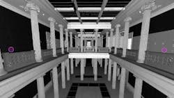
Point cloud technology has enabled greater efficiency, coordination, and collaboration in many of our renovation projects. One of the best examples is the recently completed George Washington University Corcoran School of the Arts and Design. In this project, point cloud data greatly reduced the number of site visits and potential construction issues while increasing confidence in our design.
When the project began, existing documentation of the historic 1897 gallery building in Washington, D.C. was incomplete. Historic Landmark restrictions prohibited any damage to its historically significant surfaces, which included most of the interior spaces. Point cloud data was critical to our ability to document and understand the condition of the space.
Throughout the project, our team was able to replace in-person site visits with digital “visits” to the point cloud to take measurements and verify the accuracy of as-built drawings. Where documentation was missing, such as in the building’s attic, the point cloud helped us coordinate and accelerate the surgical installation of mechanical systems. In areas where the measurement would have been challenging due to 20-30′ ceilings, we remotely measured side-wall air devices that were physically out of reach. The model also served as a robust replacement for field photos, giving us access to 360-degree views of every space in the building without leaving our desks.
This technology saved many trips to the project site, allowing for a more efficient and speedier design process. Additionally, having a shared BIM model of the building allowed design participants located throughout the region to collaborate remotely, much the same way we do now in our work-from-home environments.
There is a learning curve to doing a point cloud survey, and it was helpful that we knew in advance what directions and parameters to give the subcontractor doing the scan. Considerations such as the level of detail needed to support the model’s level of development and the degree of dimensional accuracy are critical. Converting the scan into a usable Revit model also required significant expertise, as some survey information is more useful the more accurate it is. Tight structural dimensions, for example, are important, while other important information is non-dimensional, and a high degree of dimensional accuracy may be burdensome.
A virtual alternative
As more information emerges on the likely course of the COVID-19 pandemic, it appears that restrictions placed on visits to project sites will be a part of the architecture, engineering, and construction industry’s “new normal”. Project work must continue efficiently as we all work together to adjust to this reality. This means replacing as many of our in-person meetings and site visits as possible with a virtual alternative: the point cloud.
Integrated into well-established digital design processes, point cloud technology offers a highly relevant tool in the designer’s kit. By conducting virtual site visits from our desks at home, we can limit the number, duration and group size of site visits, leading to safer, more efficient renovation projects while maintaining – and maybe even speeding up – the design process.


