flexiblefullpage
billboard
interstitial1
catfish1
Currently Reading

Google develops Google Maps for solar energy

Energy Efficiency

Google develops Google Maps for solar energy

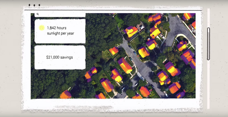
The tool offers high-resolution aerial maps, like the one used in Google Earth, to estimate the total sunlight a rooftop receives throughout the year.


By Adilla Menayang, Assistant Digital Editor | August 24, 2015
Google Develops Google Maps for Solar Energy

Users can see an estimate of how much a rooftop receives sunlight year-round. Photo: screenshot via Google/YouTube.

Deciding how much you can save on projects if you opt for solar energy is getting easier and easier. Primarily aimed at homeowners and single-family residential developers, but also useful for commercial properties, a team of Google engineers launched a new tool that can help the doubtful better understand if they will be able to bring big savings if they convert to solar energy.

Titled Project Sunroof, the tool offers high-resolution aerial maps, like the one used in Google Earth, to estimate the total sunlight a rooftop receives throughout the year, CityLab reports.

Users can then learn how much they can expect to save with solar panels, and even evaluate different financing plans.

One such application already on the market is the MIT-born MapDwell, which launched two years ago. Architizer reports that MapDwell has announced the expansion of the service into New York City’s Five Boroughs.

“This tremendous project covers over one million buildings and reveals enough high-yield photovoltaic potential to deliver over five million megawatt-hours of energy per year,” Architizer reports.

Related Stories

| Jun 30, 2011

Balancing cost and energy performance in net-zero buildings

BD+C Editorial Director Robert Cassidy talks with The Weidt Group's David Eijadi, FAIA, about the cost of producing net-zero buildings.

| Jun 29, 2011

New leadership role for architects in net-zero design

BD+C Editorial Director Rob Cassidy talks with RNL Design's Tom Hootman, AIA, about the changing role of architects in net-zero designs.

boombox1
boombox2
native1

More In Category


Government Buildings

One of the country’s first all-electric fire stations will use no outside energy sources

Charlotte, N.C.’s new Fire Station #30 will be one of the country’s first all-electric fire stations, using no outside energy sources other than diesel fuel for one or two of the fire trucks. Multiple energy sources will power the station, including solar roof panels and geothermal wells. The two-story building features three truck bays, two fire poles, dispatch area, contamination room, and gear storage.


Geothermal Technology

Rochester, Minn., plans extensive geothermal network

The city of Rochester, Minn., home of the famed Mayo Clinic, is going big on geothermal networks. The city is constructing Thermal Energy Networks (TENs) that consist of ambient pipe loops connecting multiple buildings and delivering thermal heating and cooling energy via water-source heat pumps.

halfpage1

Most Popular Content

  1. 2021 Giants 400 Report
  2. Top 150 Architecture Firms for 2019
  3. 13 projects that represent the future of affordable housing
  4. Sagrada Familia completion date pushed back due to coronavirus
  5. Top 160 Architecture Firms 2021