

The terms “desire path” and “line of desire” bring with them a bit of a mystical feeling, as if they were something Indiana Jones would need to find a way to cross to get to the Ark of the Covenant or the Holy Grail that awaits on the other side. In reality, desire paths are not quite so fantastical.
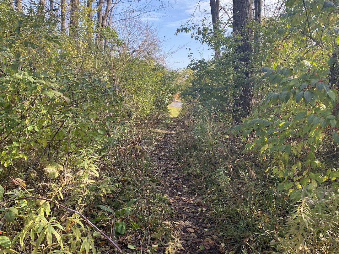
Even if you have never heard the term desire path, odds are you’ve seen one at some point. If you’ve ever been walking around a college campus, public park, or downtown area, you have probably seen an informal dirt path that cuts a corner, or through a field, or even through a few small shrubs or bushes. This path isn’t paved and clearly wasn’t part of the original plan, but thanks to the desire of many to find the path of least resistance from point A to point B, it has emerged over the years from repeated use.
Desire paths don’t necessarily have to be so rustic, either. Lines of desire can also be represented by people using formalized roads or paths in ways they were not intended to be used, such as a service road that has become a main pedestrian thoroughfare.
In general, a desire path or line of desire represents any path that end users have determined to be the most efficient way to travel, regardless of its intended use.
“They reflect the natural tendency of where people want to move. These lines are predicated on there being barrier-free environments,” says Caitlyn Clauson, Principal, Chair at Large on Board of Directors, and Planner at Sasaki. “If areas are inaccessible, for example with a steep slope or a discontinuous sidewalk, individuals will find other routes. Desire lines are often informed by adjacent land uses, especially uses with active ground floor functions and high levels of transparency and shade that make spaces inviting and habitable.”
For many, especially planners and designers, a desire path is an unsightly reminder that a campus or downtown design plan was not as efficient and pedestrian-friendly as it could have, or perhaps should have, been. It proves just because something was designed to function a certain way, it doesn’t mean end users will necessarily follow suit.
There are two solutions to the scourge of the desire path: find a way to create a space so optimally designed desire paths won’t ever rear their ugly heads, or create a space so flexible that if a desire path does appear, it can be formalized and integrated into the design.
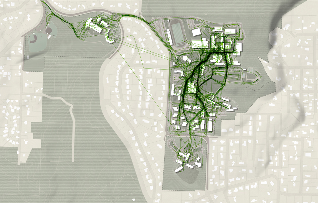
Sasaki’s CoMap helps spot ‘desire paths’ before they start
In order to prevent desire paths from taking shape, they need to be taken into consideration during a project’s earliest phases. “We did a feasibility study for UC San Diego in 2019 involving some developer land adjacent to campus and the campus architect was intrigued by my use of the term ‘line-of-desire’ in our initial meeting,” says Paul Schlapobersky, AIA, Associate Principal, Urban Designer, and Architect with Sasaki. “The entire study became about trying to ‘complete’ that line through a system of walkways and bridges connecting important nodes on the campus to this off-campus site and to newly-installed public transit beyond.”
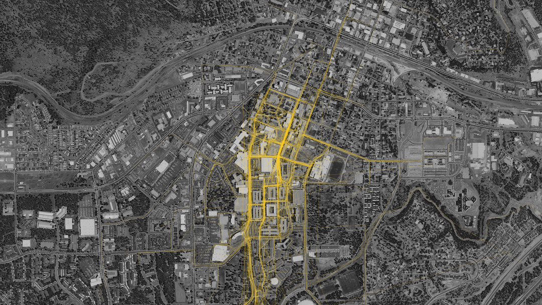
One of the main tools Sasaki uses to mitigate the informal desire path is a proprietary program developed by its in-house data and design tools group called CoMap. This collaborative mapping program generates a spatial visualization of how people experience a campus or region. When used at institutions, CoMap’s survey function allows campus communities to add notes about places or trace routes on a map of the campus. Sasaki then uses the data to inform planning recommendations.
“Many times the paths most traveled by students are not necessarily formally designed paths. The planning recommendation might therefore be to strengthen a desire line path by widening it, resurfacing it, removing an impediment, or lining it with active uses,” says Tyler Patrick, AICP, Principal, Chair of Planning and Urban Design on Board of Directors, and Planner with Sasaki. “For example, sometimes we find that service drives that are designed for vehicles are also heavily used by pedestrians, so we can instead redesign the path as more of a shared-use amenity, with aesthetic improvements to paving, lighting, etc.”
At one university, Sasaki used CoMap to learn that the formal entry to the campus was rarely used and the service drive actually served as the primary pedestrian route into campus. The design team took this information and reoriented the campus and created a new “front door” where the service drive used to be, with service access still accommodated, but in a more understated manner.
Sasaki also used CoMap in a master planning effort the firm led for Lewis & Clark College. The CoMap survey highlighted a strong north-south pedestrian route along an existing road. In response to the user feedback from CoMap, Sasaki turned the route into a primary pedestrian promenade on campus, surrounded by new residential and student life facilities.

CoMap is just one strategy the firm uses to create efficient plans without any informal desire paths. “We employ a range of strategies that include analyzing the existing system of pathways (what forms of mobility they support, their width, condition, amenities, etc.); collecting a variety of data (for instance, looking at where the concentration of classrooms is, as well as classroom utilization, to see key areas between which students may be moving); and conducting interviews and surveys to learn how pathways are used, deficiencies in the overall system, and desire paths that have not been formalized,” says Patrick.
Desire paths do not always equal good design
Just because an informal desire path appears, it does not mean it should always be formalized. Especially if the path is in direct conflict with the greater overall design scheme. “For instance, students may want to formally cross through a recreation field, but we want to maintain the field’s integrity for recreation and so we wouldn’t want to formalize that kind of desire path,” Patrick says.
Other instances may include environmental or safety concerns, such as wanting to keep a stream side riparian system intact as opposed to introducing formalized pedestrian pathways. “If a desire line promotes a path that isn’t accessible, we likely would not want to promote that movement,” adds Clauson.
The key is to balance how people want to use a given space without it turning into a free-for-all. Desire paths can, and often times do, suggest improvements for pedestrian circulation, but blindly formalizing any desire path can easily lead to a one step forward, two steps back situation. As Patrick said above, a desire path that cuts through a recreation field may prove that it is the most efficient way to traverse a campus, but formalizing it would certainly lead to more complaints about a now fractured field that is much more of an inconvenience than the lack of a formal path ever was.
As is often the case in modern design, the benefits of flexibility should never be understated. “A good campus plan should be flexible enough to accommodate evolving patterns of use and allow for the campus to integrate new ideas into the framework,” Patrick says.
The desire path, then, is representative of a larger point: There is no such thing as a perfect design, but there can be a perfectly adaptable one. Having the ability to continually adjust and formally adapt to the desires of end users is the best way to achieve the highest possible efficiency for any design.
Related Stories
| Aug 11, 2010
LA high school takes design cue from historic Mexican architecture
The Los Angeles Unified School District recently opened the $75 million Felicitas and Gonzalo Mendez Learning Center, a high school in the Los Angeles neighborhood of Boyle Heights, near Little Tokyo. Designed by Nadel Architects in a joint venture with Barrio Planners Inc., the 114,000-sf school is vertically integrated, allowing the campus to fit on a compact, six-acre site.
| Aug 11, 2010
Take the hassle out of managing subcontractors
As general contractors look to technology for an edge in the slowing commercial construction market, Web-based bidding programs are helping them to connecting bid information, subcontractors, and proposals. A 2008 survey by the Construction Financial Management Association found that 62% of general contractors participated in Web-based construction bidding vs.
| Aug 11, 2010
Toronto mandates green roofs
The city of Toronto late last month passed a new green roof by-law that consists of a green roof construction standard and a mandatory requirement for green roofs on all classes of new buildings. The by-law requires up to 50% green roof coverage on multi-unit residential dwellings over six stories, schools, nonprofit housing, and commercial and industrial buildings.
| Aug 11, 2010
Carpenters' union helping build its own headquarters
The New England Regional Council of Carpenters headquarters in Dorchester, Mass., is taking shape within a 1940s industrial building. The Building Team of ADD Inc., RDK Engineers, Suffolk Construction, and the carpenters' Joint Apprenticeship Training Committee, is giving the old facility a modern makeover by converting the existing two-story structure into a three-story, 75,000-sf, LEED-certif...
| Aug 11, 2010
TCF Bank Stadium first new football stadium to get LEED certification
The University of Minnesota has received LEED Silver certification for its 50,805-seat TCF Bank Stadium, making it the first new football stadium in the country to achieve LEED status. Designed by Populous, Kansas City, Mo., the facility features a stormwater management system that captures and stores rainwater in an underground filtering system, where it is harvested, filtered, and drained int...
| Aug 11, 2010
Nursing home turned charter school opens in Dorchester, Mass.
Cambridge, Mass.-based HMFH Architects spearheaded the design for the conversion of a former nursing home in Dorchester, Mass., to learning and community space for the Neighborhood House Charter School. The pre-K—8 school has two classrooms for each elementary grade level, clusters of middle school classrooms, a cafeteria, media center, and art, computer, music and science classrooms.
| Aug 11, 2010
High-level NICU opens in Washington, D.C.
Design to the highest distinction available by the American Academy of Pediatrics, the new Level IIIC neonatal intensive care unit (NICU) at Children's National Medical Center in Washington D.C., is equipped to care for the sickest premature babies, including those that require open-heart surgery. The 54-bed facility, designed by Karlsberger with KLMK Group as space planner, is four times large...
| Aug 11, 2010
Office complex will incorporate a bit of Summit, N.J., history
Greenock Capital Management and CB Richard Ellis have broken ground on the 46,570-sf Claremont Corporate Center in Summit, N.J. The two-story, Class A office complex will incorporate the adjacent turn-of-the-century Risk Mansion, family home of Dr. William H. Risk, who settled in Summit in 1873. The mansion will be the focus of the facility, with new, modern offices and below-grade parking cons...
| Aug 11, 2010
RMJM unveils design details for $1B green development in Turkey
RMJM has unveiled the design for the $1 billion Varyap Meridian development it is master planning in Istanbul, Turkey's Atasehir district, a new residential and business district. Set on a highly visible site that features panoramic views stretching from the Bosporus Strait in the west to the Sea of Marmara to the south, the 372,000-square-meter development includes a 60-story tower, 1,500 resi...
| Aug 11, 2010
Utah research facility reflects Native American architecture
A $130 million research facility is being built at University of Utah's Salt Lake City campus. The James L. Sorenson Molecular Biotechnology Building—a USTAR Innovation Center—is being designed by the Atlanta office of Lord Aeck & Sargent, in association with Salt-Lake City-based Architectural Nexus.


