

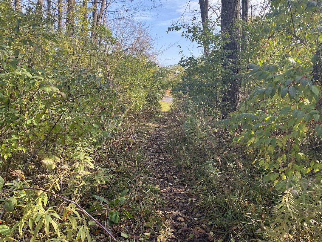
The terms “desire path” and “line of desire” bring with them a bit of a mystical feeling, as if they were something Indiana Jones would need to find a way to cross to get to the Ark of the Covenant or the Holy Grail that awaits on the other side. In reality, desire paths are not quite so fantastical.
Even if you have never heard the term desire path, odds are you’ve seen one at some point. If you’ve ever been walking around a college campus, public park, or downtown area, you have probably seen an informal dirt path that cuts a corner, or through a field, or even through a few small shrubs or bushes. This path isn’t paved and clearly wasn’t part of the original plan, but thanks to the desire of many to find the path of least resistance from point A to point B, it has emerged over the years from repeated use.
Desire paths don’t necessarily have to be so rustic, either. Lines of desire can also be represented by people using formalized roads or paths in ways they were not intended to be used, such as a service road that has become a main pedestrian thoroughfare.
In general, a desire path or line of desire represents any path that end users have determined to be the most efficient way to travel, regardless of its intended use.
“They reflect the natural tendency of where people want to move. These lines are predicated on there being barrier-free environments,” says Caitlyn Clauson, Principal, Chair at Large on Board of Directors, and Planner at Sasaki. “If areas are inaccessible, for example with a steep slope or a discontinuous sidewalk, individuals will find other routes. Desire lines are often informed by adjacent land uses, especially uses with active ground floor functions and high levels of transparency and shade that make spaces inviting and habitable.”
For many, especially planners and designers, a desire path is an unsightly reminder that a campus or downtown design plan was not as efficient and pedestrian-friendly as it could have, or perhaps should have, been. It proves just because something was designed to function a certain way, it doesn’t mean end users will necessarily follow suit.
There are two solutions to the scourge of the desire path: find a way to create a space so optimally designed desire paths won’t ever rear their ugly heads, or create a space so flexible that if a desire path does appear, it can be formalized and integrated into the design.
Sasaki’s CoMap helps spot ‘desire paths’ before they start
In order to prevent desire paths from taking shape, they need to be taken into consideration during a project’s earliest phases. “We did a feasibility study for UC San Diego in 2019 involving some developer land adjacent to campus and the campus architect was intrigued by my use of the term ‘line-of-desire’ in our initial meeting,” says Paul Schlapobersky, AIA, Associate Principal, Urban Designer, and Architect with Sasaki. “The entire study became about trying to ‘complete’ that line through a system of walkways and bridges connecting important nodes on the campus to this off-campus site and to newly-installed public transit beyond.”
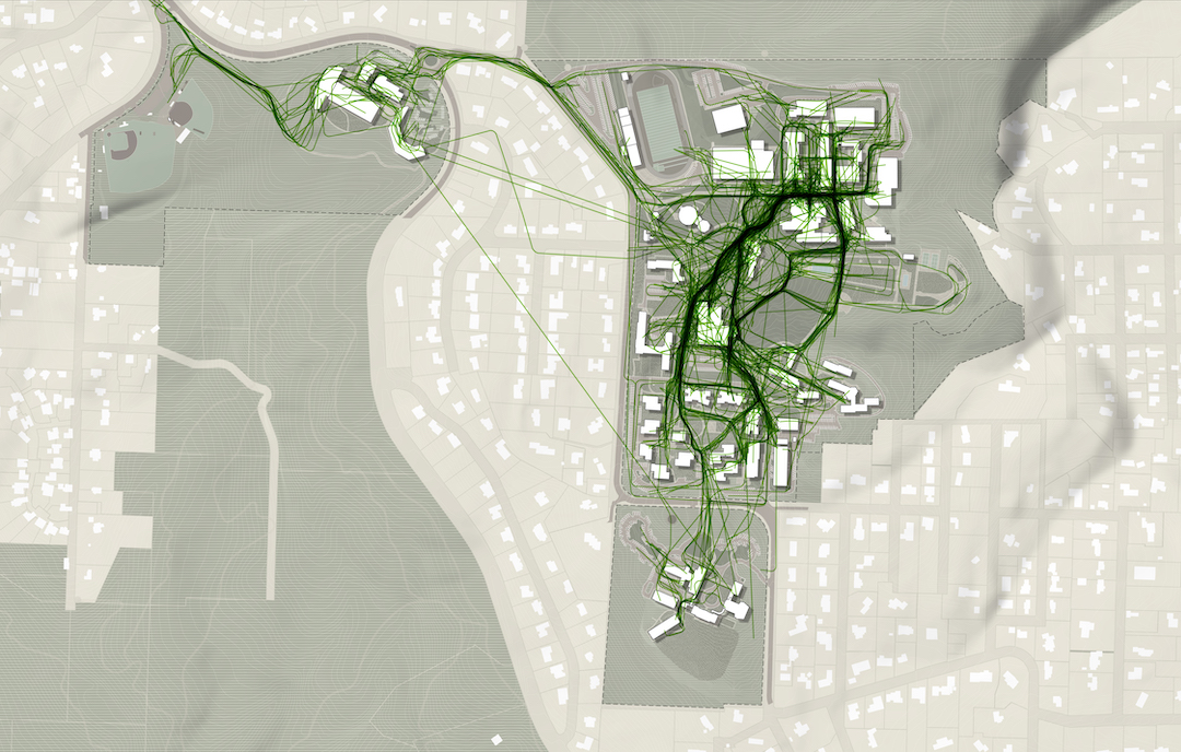
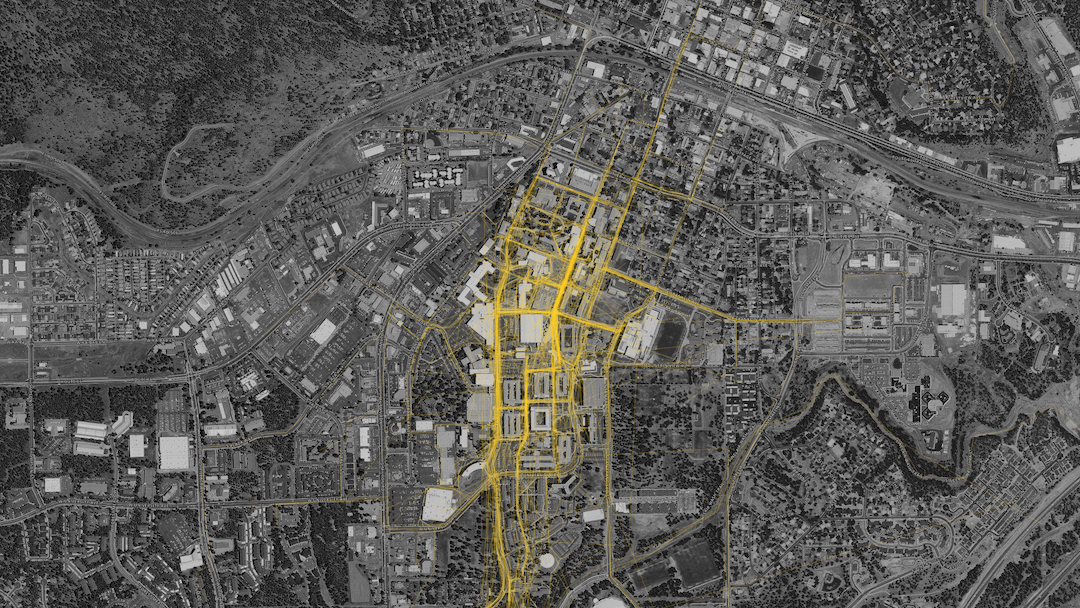
One of the main tools Sasaki uses to mitigate the informal desire path is a proprietary program developed by its in-house data and design tools group called CoMap. This collaborative mapping program generates a spatial visualization of how people experience a campus or region. When used at institutions, CoMap’s survey function allows campus communities to add notes about places or trace routes on a map of the campus. Sasaki then uses the data to inform planning recommendations.
“Many times the paths most traveled by students are not necessarily formally designed paths. The planning recommendation might therefore be to strengthen a desire line path by widening it, resurfacing it, removing an impediment, or lining it with active uses,” says Tyler Patrick, AICP, Principal, Chair of Planning and Urban Design on Board of Directors, and Planner with Sasaki. “For example, sometimes we find that service drives that are designed for vehicles are also heavily used by pedestrians, so we can instead redesign the path as more of a shared-use amenity, with aesthetic improvements to paving, lighting, etc.”
At one university, Sasaki used CoMap to learn that the formal entry to the campus was rarely used and the service drive actually served as the primary pedestrian route into campus. The design team took this information and reoriented the campus and created a new “front door” where the service drive used to be, with service access still accommodated, but in a more understated manner.
Sasaki also used CoMap in a master planning effort the firm led for Lewis & Clark College. The CoMap survey highlighted a strong north-south pedestrian route along an existing road. In response to the user feedback from CoMap, Sasaki turned the route into a primary pedestrian promenade on campus, surrounded by new residential and student life facilities.

CoMap is just one strategy the firm uses to create efficient plans without any informal desire paths. “We employ a range of strategies that include analyzing the existing system of pathways (what forms of mobility they support, their width, condition, amenities, etc.); collecting a variety of data (for instance, looking at where the concentration of classrooms is, as well as classroom utilization, to see key areas between which students may be moving); and conducting interviews and surveys to learn how pathways are used, deficiencies in the overall system, and desire paths that have not been formalized,” says Patrick.
Desire paths do not always equal good design
Just because an informal desire path appears, it does not mean it should always be formalized. Especially if the path is in direct conflict with the greater overall design scheme. “For instance, students may want to formally cross through a recreation field, but we want to maintain the field’s integrity for recreation and so we wouldn’t want to formalize that kind of desire path,” Patrick says.
Other instances may include environmental or safety concerns, such as wanting to keep a stream side riparian system intact as opposed to introducing formalized pedestrian pathways. “If a desire line promotes a path that isn’t accessible, we likely would not want to promote that movement,” adds Clauson.
The key is to balance how people want to use a given space without it turning into a free-for-all. Desire paths can, and often times do, suggest improvements for pedestrian circulation, but blindly formalizing any desire path can easily lead to a one step forward, two steps back situation. As Patrick said above, a desire path that cuts through a recreation field may prove that it is the most efficient way to traverse a campus, but formalizing it would certainly lead to more complaints about a now fractured field that is much more of an inconvenience than the lack of a formal path ever was.
As is often the case in modern design, the benefits of flexibility should never be understated. “A good campus plan should be flexible enough to accommodate evolving patterns of use and allow for the campus to integrate new ideas into the framework,” Patrick says.
The desire path, then, is representative of a larger point: There is no such thing as a perfect design, but there can be a perfectly adaptable one. Having the ability to continually adjust and formally adapt to the desires of end users is the best way to achieve the highest possible efficiency for any design.
Related Stories
| Aug 11, 2010
Dave Barista named chief editor of Professional Builder
David Barista has assumed the chief editor position at Professional Builder, a Reed Business Information (RBI) publication, with additional responsibility for Custom Builder, Housing Giants, and HousingZone. Barista joined RBI in 2000, shortly after graduating from Eastern Illinois University, as an editor with Building Design+Construction.
| Aug 11, 2010
And the world's tallest building is…
At more than 2,600 feet high, the Burj Dubai (right) can still lay claim to the title of world's tallest building—although like all other super-tall buildings, its exact height will have to be recalculated now that the Council on Tall Buildings and Urban Habitat (CTBUH) announced a change to its height criteria.
| Aug 11, 2010
Project is music to school's ears
Florida Gulf Coast University is building a $7.55 million Fine Arts Building on its campus near Ft. Myers, Fla. The 25,000-sf building—the first project in the school's plan for an entire music complex—will house the music program of the College of Arts and Sciences. The facility includes a 200-seat recital hall, rehearsal hall, music labs, studio rooms, and administration offices.
| Aug 11, 2010
East meets West in hospital design
The Los Angeles office of HMC Architects and the Chinese firm Shunde Architectural Design Institute won the commission to design the 2.15 million-sf First People's Hospital in the Shunde District of Foshan, China. The team's winning concept organizes a series of buildings around a dynamic, curved spine element to create an interior “eco-atrium” with outdoor green space and healing g...
| Aug 11, 2010
Voting center redesigned where it counts
A series of large-scale photographic banners by artist Rebeca Mendez soars above the newly redesigned Los Angeles County Elections Operations Center. L.A.-based Lehrer Architects completely reworked the 110,000-sf concrete warehouse, adding a new floor plan that improves work flow, bold colors, 12-foot-high dividing walls, and original artwork to create a vibrant and people-friendly environment.
| Aug 11, 2010
New pavilion planned for famous boulevard
Located in a prime spot along Santa Monica Boulevard in the Westwood neighborhood of Los Angeles, the Santa Monica Pavilion will have 9,000 sf of retail space, 35,500 sf of office space, and two below-grade parking levels when it opens in late 2010. The $10 million, three-story building extends a full length of the block to create a window wall of blue-gray translucent, fritted glass panels ove...
| Aug 11, 2010
Luxury high-rise meets major milestone
A topping off ceremony was held in late October for 400 Fifth Avenue, a 57,000-sf high-rise that includes a 214-room luxury hotel and 190 high-end residential condominiums. Developed by Bizzi & Partners Development and designed by Gwathmey Siegel & Associates Architects, the 60-story tower in midtown Manhattan sits atop a smaller-scale 10-story base, which creates a street façade t...
| Aug 11, 2010
New building focuses on public safety
The $40 million public safety building for the city of El Cajon, Calif., is under construction and slated for completion in June 2011. The five-story, 119,400-sf building will house the city’s administrative offices, a joint police and fire emergency operations center, central data center, indoor firing range, crime lab, and short-term custody facility.
| Aug 11, 2010
MOB added to new hospital project
A late-2009 ground breaking is planned for a $20 million medical office building on the grounds of the $211 million, 106-bed Loma Linda University Medical Center in Murrieta, Calif., which itself is under construction. Minneapolis-based Frauenshuh HealthCare Real Estate Solutions is developing the five-story, 160,000-sf MOB, which will accommodate 60 physician offices.
| Aug 11, 2010
Firm goes for Gold with office design
DLR Group is designing its new Omaha, Neb., headquarters to achieve LEED Gold. Sustainable features being incorporated into the three-story, 39,000-sf building, which is part of the city’s new Aksarben Village mixed-use development, include daylighting, outdoor workspaces, native landscaping, a green roof, and the pursuit of renewable energy credits.


