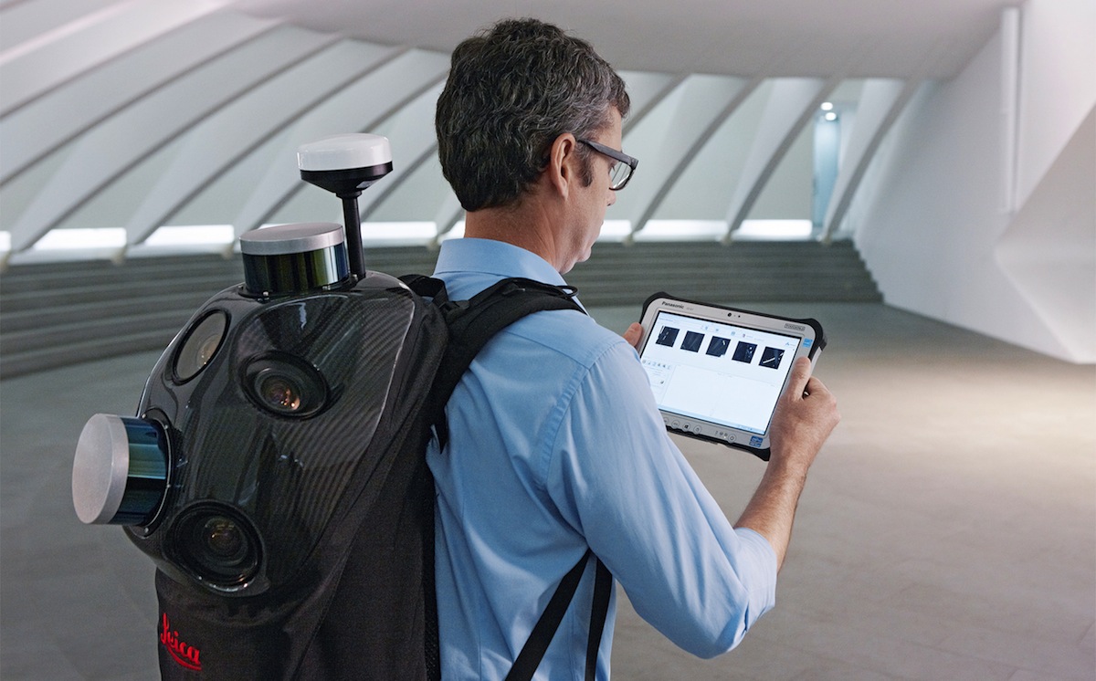
Leica Geosystems announced the industry’s first commercially available wearable reality-capture technology with the Pegasus:Backpack at HxGN LIVE.
Combining five high-dynamic cameras, which work in a variety of light conditions, and a LiDAR profiler with an ultra-light and ergonomic carbon fiber chassis, this mobile mapping solution creates a 3D view indoors or outdoors for engineering or professional documentation creation at the highest level of authority yet.
For BIM or simply for capturing 2D square foot updates to a large building, the Leica Pegasus:Backpack creates the most realistic view by capturing synchronized imagery and point cloud data. Accurate positioning is achieved in GNSS-restricted areas using Simultaneous Localization and Mapping, or SLAM, technology. Together with a high precision inertial measurement unit, the Leica Pegasus:Backpack is the first position-agnostic solution.
This new technology is designed to enable weekly data capture efficiently and cost effectively for changing building construction sites. For the first time, this enables the creation of a full starting document for authoritative 6D management of a building or simply to provide an authoritative hand-off dataset to a new building owner. By capturing weekly during a building’s construction, an “x-ray” view of the building is created. As the Backpack clearly logs position and time with the advanced measurement of LiDAR, change orders in the construction process can now offer a complete new level of authority for quality construction while scheduled milestones are achieved.
With full 360-spherical views and LiDAR together plus a hardware light sensor, all images are usable while other functions are verifiable and adjustable over the operator’s tablet device. The system uses multiple hot-swappable batteries, making even long captures possible.
“With the Leica Pegasus:Backpack, limited-access outdoor areas or underground infrastructures are no longer limited in professional data collection,” said Stuart Woods, Geospatial Solutions Division vice-president. “Users will never again forget any aspect of any job nor need to return to a project site. They can capture everything by simply arriving on site wearing the technology, capture and leave, rest assured they have everything they need to complete the job on time and on budget.”
Working with images and point clouds together, data is captured into a single platform and workflow – from the operator interface to a single-click post-processing to feature Meta tagging. Leveraging Leica’s Mapfactory extension, features can be extracted and datasets can be exported to CAD or BIM specific software solutions. More effective decision making is finally achieved with 3D spatial models that allow for true life cycle building planning, enabling 6D BIM.
Related Stories
| Jun 28, 2013
Building owners cite BIM/VDC as 'most exciting trend' in facilities management, says Mortenson report
A recent survey of more than 60 building owners and facility management professionals by Mortenson Construction shows that BIM/VDC is top of mind among owner professionals.
| Jun 20, 2013
Virtual meetings enhance design of University at Buffalo Medical School
HOK designers in New York, St. Louis and Atlanta are using virtual meetings with their University at Buffalo (UB) client team to improve the design process for UB’s new School of Medicine and Biomedical Sciences on the Buffalo Niagara Medical Campus.
| Jun 12, 2013
‘Talking’ Braille maps help the visual impaired
Talking pen technology, combined with tactile maps, allows blind people to more easily make their way around BART stations in the Bay Area.
| May 30, 2013
5 tips for running a successful BIM coordination meeting
BIM modeling tools are great, but if you can't run efficient, productive coordination meetings, the Building Team will never realize the benefits of true BIM coordination. Here are some helpful tips for making the most of coordination meetings.
| May 6, 2013
SAFTI FIRST announces 3D Autodesk Revit models for fire rated wall, window, and door systems
SAFTI FIRST, leading USA-manufacturer of fire rated glass and faming systems, is proud to announce that Autodesk Revit models are now available for its fire rated walls, window and door systems via www.safti.com and Autodesk Seek.
| May 1, 2013
A LEGO lover's dream: Guide to building the world's iconic structures with LEGO
A new book from LEGO master builder Warren Elsmore offers instructions for creating scale models of buildings and landmarks with LEGO.
| Apr 18, 2013
Bluebeam Software releases Revu 11 for organizing project data and collaborating anytime, anywhere, even offline
Bluebeam® Software, leading developer of PDF-based collaboration solutions, announced the release of Revu® 11. This new version of Bluebeam’s flagship solution makes it easier than ever for users in document-intensive industries including architecture, engineering and construction (AEC) and oil and gas to collaborate on project documents and digitize technical reviews.
| Apr 15, 2013
Using software and the power of the cloud to connect your back office to your field operations [webinar]
This webinar will focus on a new software subscription service that will help construction companies, general and specialty contractors connect their back office infrastructure with all of their field operations. The service will help capture, manage and report on the progress of existing construction jobs and help in the planning of new ones.
| Apr 6, 2013
Bentley’s inaugural Chief Donald J. Burns Memorial Research Grant awarded to University of Texas Group
Bentley Systems, Incorporated, the leading company dedicated to providing comprehensive software solutions for sustaining infrastructure, today announced that the Chief Donald J. Burns Research Grant for 2012 has been awarded on its behalf to Dr. Ofodike Ezekoye and Austin Anderson, of the University of Texas Fire Research Group (UTFRG), by the Society of Fire Protection Engineers (SFPE) Scientific and Educational Foundation.


