


Leica Geosystems announced the industry’s first commercially available wearable reality-capture technology with the Pegasus:Backpack at HxGN LIVE.
Combining five high-dynamic cameras, which work in a variety of light conditions, and a LiDAR profiler with an ultra-light and ergonomic carbon fiber chassis, this mobile mapping solution creates a 3D view indoors or outdoors for engineering or professional documentation creation at the highest level of authority yet.
For BIM or simply for capturing 2D square foot updates to a large building, the Leica Pegasus:Backpack creates the most realistic view by capturing synchronized imagery and point cloud data. Accurate positioning is achieved in GNSS-restricted areas using Simultaneous Localization and Mapping, or SLAM, technology. Together with a high precision inertial measurement unit, the Leica Pegasus:Backpack is the first position-agnostic solution.
This new technology is designed to enable weekly data capture efficiently and cost effectively for changing building construction sites. For the first time, this enables the creation of a full starting document for authoritative 6D management of a building or simply to provide an authoritative hand-off dataset to a new building owner. By capturing weekly during a building’s construction, an “x-ray” view of the building is created. As the Backpack clearly logs position and time with the advanced measurement of LiDAR, change orders in the construction process can now offer a complete new level of authority for quality construction while scheduled milestones are achieved.
With full 360-spherical views and LiDAR together plus a hardware light sensor, all images are usable while other functions are verifiable and adjustable over the operator’s tablet device. The system uses multiple hot-swappable batteries, making even long captures possible.
“With the Leica Pegasus:Backpack, limited-access outdoor areas or underground infrastructures are no longer limited in professional data collection,” said Stuart Woods, Geospatial Solutions Division vice-president. “Users will never again forget any aspect of any job nor need to return to a project site. They can capture everything by simply arriving on site wearing the technology, capture and leave, rest assured they have everything they need to complete the job on time and on budget.”
Working with images and point clouds together, data is captured into a single platform and workflow – from the operator interface to a single-click post-processing to feature Meta tagging. Leveraging Leica’s Mapfactory extension, features can be extracted and datasets can be exported to CAD or BIM specific software solutions. More effective decision making is finally achieved with 3D spatial models that allow for true life cycle building planning, enabling 6D BIM.
Related Stories

Sponsored | | Apr 17, 2014
Technology enables state transportation agency to make the leap to digital design review
Earlier this month, my colleague and I presented a session to a group of civil engineers and transportation agencies about the tech trends in the AEC space. Along with advice on how to prepare your plan for controlled collaboration, we also talked through some practical use cases. One such use case was especially interesting, as it outlined a challenge not unfamiliar to government agencies who are contemplating the leap from paper to digital processes: how to securely migrate workflows.

| Apr 10, 2014
Submit Your Project for a Bluebeam eXtreme Award!
Bluebeam is holding the second annual Bluebeam eXtreme Awards at the 2014 Bluebeam eXtreme Conference in Hollywood, Calf.

| Apr 3, 2014
Security, accountability, and cloud access: Can you really have it all?
I’ve heard countless stories of conversations between project engineers and IT professionals who can’t come to an agreement on the level of security needed to protect their data while making it more accessible—not only externally, but also internally.
| Apr 2, 2014
New Autodesk software allows visualization of more realistic bridge concepts
The Autodesk InfraWorks 360 family of offerings now includes enhanced roads and highways capabilities, better representations of graphical information, and fixed-length pipe modeling capability.

| Mar 26, 2014
Zaha Hadid's glimmering 'cultural hub of Seoul' opens with fashion, flair [slideshow]
The new space, the Dongdaemun Design Plaza, is a blend of park and cultural spaces meant for the public to enjoy.

| Mar 20, 2014
Fluor defines the future 7D deliverable without losing sight of real results today
A fascinating client story by Fluor SVP Robert Prieto reminds us that sometimes it’s the simplest details that can bring about real results today—and we shouldn’t overlook them, even as we push to change the future state of project facilitation.
| Mar 12, 2014
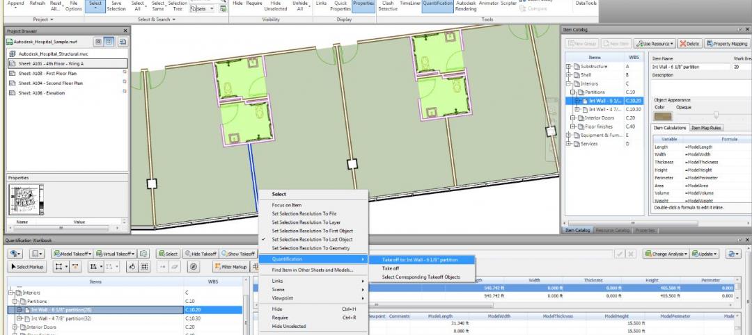
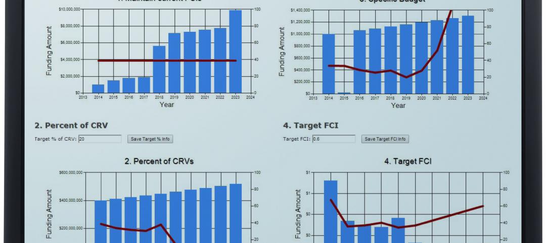
New CannonDesign database allows users to track facility assets
The new software identifies critical failures of components and systems, code and ADA-compliance issues, and systematically justifies prudent expenditures.

| Mar 10, 2014
Meet Tally – the Revit app that calculates the environmental impact of building materials
Tally provides AEC professionals with insight into how materials-related decisions made during design influence a building’s overall ecological footprint.

| Mar 10, 2014
Field tested: Caterpillar’s Cat B15 rugged smartphone
The B15 is billed by Cat as “the most progressive, durable and rugged device available on the market today.”

| Mar 10, 2014
5 rugged mobile devices geared for construction pros
BD+C readers share their most trusted smartphone and tablet cases. The editors select some of their faves, too.


