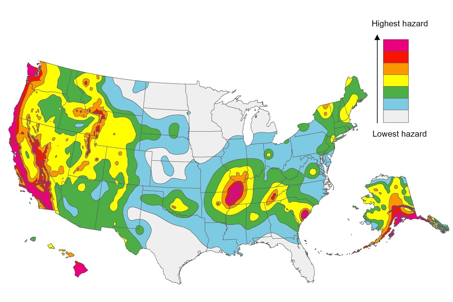
The U.S. Geological Service recently released an update of U.S. National Seismic Hazard Maps that reflect the latest analysis of where future earthquakes will occur, how frequently they may occur, and their strength.
While all states have some potential for earthquakes, 42 of the 50 states have a reasonable chance of experiencing damaging ground shaking from an earthquake in the next 50 years. Sixteen states have a relatively high likelihood of experiencing damaging ground shaking. These states have historically experienced earthquakes with a magnitude 6 or greater. The hazard is especially high along the west coast, intermountain west, and in several active regions elsewhere such as near New Madrid, Mo., and near Charleston, S.C.
The eastern U.S. has the potential for larger and more damaging earthquakes than considered in previous maps and assessments. This finding is due to what scientists learned following the magnitude 5.8 earthquakes that struck Virginia in 2011. It was among the largest earthquakes to occur along the east coast in the last century, and indicated that even larger events in the region are possible.
The maps are used in risk analyses calculated using factors such as population levels, building exposure, and building construction practices. These assessments are used for establishing building codes, in the analysis of seismic risk for key structures, and in determining insurance rates. They can also aid emergency preparedness plans, and private property decisions such as re-evaluating one’s real estate and making it more resilient.
(http://www.usgs.gov/blogs/features/usgs_top_story/new-insight-on-the-nations-earthquake-hazards/)
Related Stories
| Aug 20, 2013
L.A. City Council approves plan for new $1 billion Watts development
Los Angeles city officials have voted to revitalize a notorious Watts housing project with shops, town homes, and green spaces.
| Aug 19, 2013
Baltimore City Council committee OKs taxpayer assistance for $1.8 billion Harbor Point mixed-use project
A Baltimore City Council committee approved a plan to give millions in taxpayer assistance to the $1.8 billion Harbor Point development.
| Aug 19, 2013
Philadelphia to enforce building energy benchmarking in October
The City of Philadelphia has begun to send out compliance notices regarding its Building Energy Benchmarking Law.
| Aug 19, 2013
Eliminating Fannie Mae, Freddie Mac part of Obama’s housing proposal
President Barack Obama this month outlined a series of policies he said would continue to boost the housing market, including a long-ignored legislative proposal that would allow more Americans to refinance at current low mortgage rates.
| Aug 19, 2013
HUD, New York City collaborate on research center to boost storm resilience
The U.S. Housing and Urban Development Department and New York City will collaborate on a project to create a new research institute and a city-federal park at Jamaica Bay, Queens.
| Aug 16, 2013
Dept. of Homeland Security offers tool to analyze building risk and resilience
The Integrated Rapid Visual Screening tool is designed to determine initial or relative risk and resilience for buildings based on visual inspection only.
| Aug 8, 2013
AAMA releases specification for non-residential fenestration BIM
The American Architectural Manufacturers Association (AAMA) released AAMA 912-13, Voluntary Specification for Non-Residential Fenestration Building Information Modeling (BIM).
| Aug 8, 2013
New green property index could boost REIT investment in more sustainable properties
A project by the National Association of Real Estate Investment Trusts (NAREIT), the FTSE Group, and the U.S. Green Building Council to jointly develop a Green Property Index could help REITs attract some of the growing pool of socially responsible investment money slated for green investments.
| Aug 8, 2013
Boston reaching for solutions to threat of rising sea levels on waterfront development
While Boston officials consider whether to enact new building codes to resist flooding stemming from climate change-induced rising sea levels, developers are already boosting resiliency on new projects.
| Aug 8, 2013
EPA’s National Stormwater Calculator aids developers
The Environmental Protection Agency has released an application called the National Stormwater Calculator that uses soil conditions and rainfall records to estimate annual rainfall and runoff for any location in the U.S.


