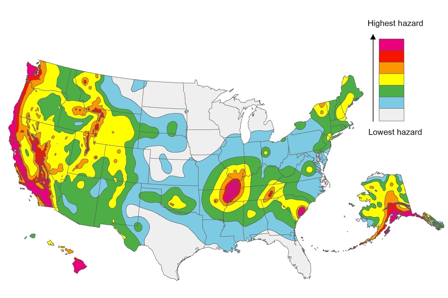
The U.S. Geological Service recently released an update of U.S. National Seismic Hazard Maps that reflect the latest analysis of where future earthquakes will occur, how frequently they may occur, and their strength.
While all states have some potential for earthquakes, 42 of the 50 states have a reasonable chance of experiencing damaging ground shaking from an earthquake in the next 50 years. Sixteen states have a relatively high likelihood of experiencing damaging ground shaking. These states have historically experienced earthquakes with a magnitude 6 or greater. The hazard is especially high along the west coast, intermountain west, and in several active regions elsewhere such as near New Madrid, Mo., and near Charleston, S.C.
The eastern U.S. has the potential for larger and more damaging earthquakes than considered in previous maps and assessments. This finding is due to what scientists learned following the magnitude 5.8 earthquakes that struck Virginia in 2011. It was among the largest earthquakes to occur along the east coast in the last century, and indicated that even larger events in the region are possible.
The maps are used in risk analyses calculated using factors such as population levels, building exposure, and building construction practices. These assessments are used for establishing building codes, in the analysis of seismic risk for key structures, and in determining insurance rates. They can also aid emergency preparedness plans, and private property decisions such as re-evaluating one’s real estate and making it more resilient.
(http://www.usgs.gov/blogs/features/usgs_top_story/new-insight-on-the-nations-earthquake-hazards/)
Related Stories
| Oct 16, 2014
Energy Department sets green building standards for federal agencies
LEED Silver may be used, and in some instances, the Green Globes program may be substituted, according to a new regulation by the U.S. Department of Energy.
| Oct 16, 2014
New York City’s climate plan includes tripling of solar energy
New York City’s plan to cut greenhouse gas emissions by 80% by 2050 includes tripling the amount of solar power generated from city-owned buildings.
| Oct 15, 2014
Drones may soon assist code inspectors for construction in the UAE
The United Arab Emirates’ Ministry of Labour announced that they will start using drones to help inspectors record when construction sites are breaking laws.
| Oct 9, 2014
California authorizes increased use of design-build on state projects
Under the updated law, the Department of General Services and the Department of Corrections and Rehabilitation may use design-build on projects in excess of $1 million.
| Oct 9, 2014
New York City releases guide for retrofitting buildings against floods
Part of the city’s response to widespread flooding as a result of Hurricane Sandy, the manual offers retrofitting strategies that will enable property owners to reduce the risk of damage and disruption from coastal flooding.
| Oct 9, 2014
Seattle puts restrictions on micro apartments
The Seattle City Council passed new rules that new studio apartments in the city must measure at least 220 sf and contain at least two sinks.
| Oct 9, 2014
Cities get creative with stormwater management
Cities around the world are crafting stormwater management policies that include natural and manmade methods to store and absorb runoff to reduce flooding.
| Oct 2, 2014
Fannie Mae study says affordable rental units more energy efficient than market-rate units
Fannie Mae’s new report on energy usage in the multifamily sector found that affordable properties use 28% less energy per unit and are 29% smaller than market-rate properties.
| Oct 2, 2014
California Energy Commission launches code upgrade process
The California Energy Commission launched the upgrade process to Title 24, the state energy code, last month.
| Oct 2, 2014
Canals to mitigate flooding could be in Boston’s future
The Urban Land Institute held brainstorming sessions over the last several months involving more than 70 engineers, architects, and development and insurance specialists to examine how rising sea levels would affect four representative areas in and around Boston.


