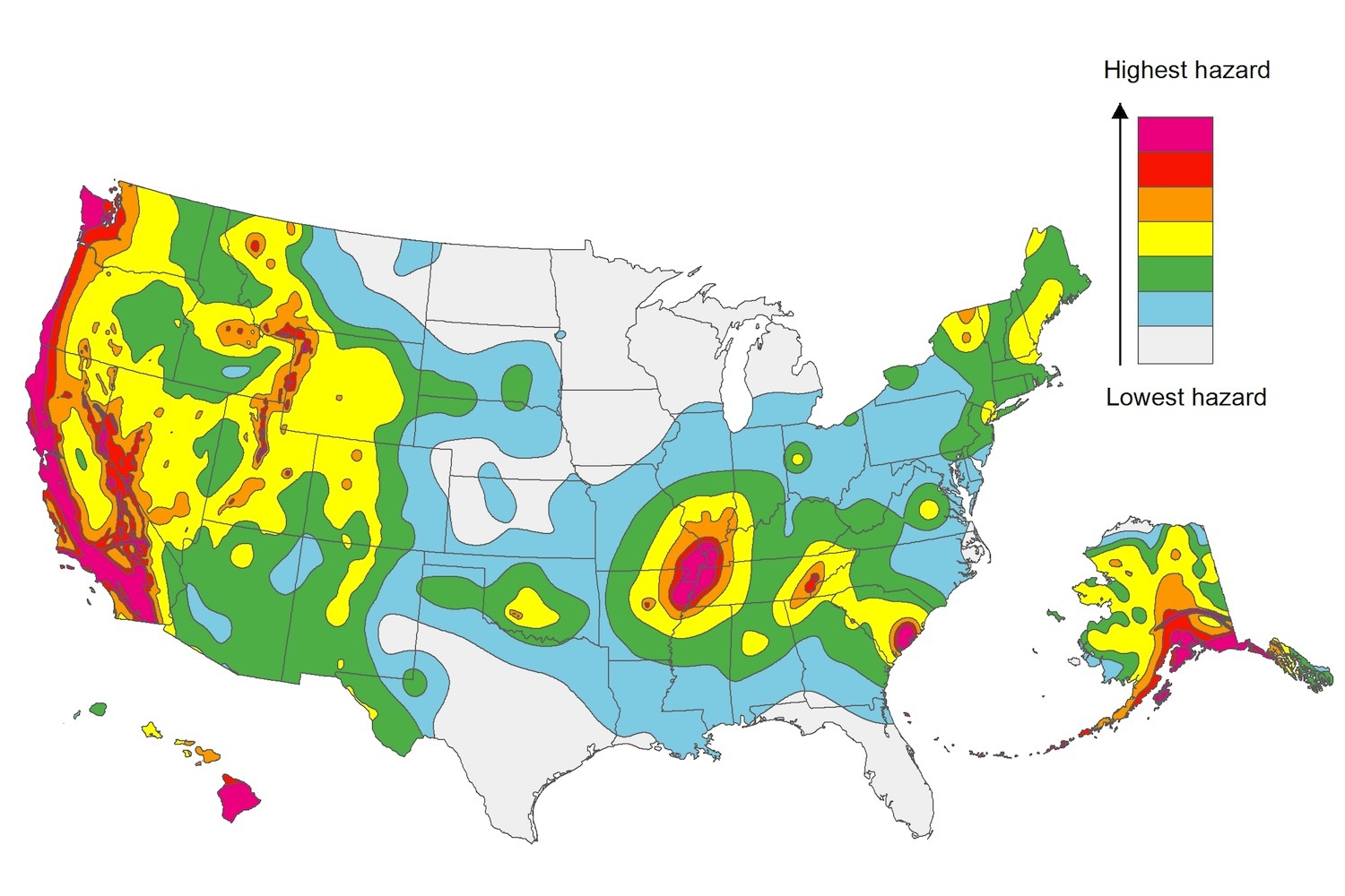
The U.S. Geological Service recently released an update of U.S. National Seismic Hazard Maps that reflect the latest analysis of where future earthquakes will occur, how frequently they may occur, and their strength.
While all states have some potential for earthquakes, 42 of the 50 states have a reasonable chance of experiencing damaging ground shaking from an earthquake in the next 50 years. Sixteen states have a relatively high likelihood of experiencing damaging ground shaking. These states have historically experienced earthquakes with a magnitude 6 or greater. The hazard is especially high along the west coast, intermountain west, and in several active regions elsewhere such as near New Madrid, Mo., and near Charleston, S.C.
The eastern U.S. has the potential for larger and more damaging earthquakes than considered in previous maps and assessments. This finding is due to what scientists learned following the magnitude 5.8 earthquakes that struck Virginia in 2011. It was among the largest earthquakes to occur along the east coast in the last century, and indicated that even larger events in the region are possible.
The maps are used in risk analyses calculated using factors such as population levels, building exposure, and building construction practices. These assessments are used for establishing building codes, in the analysis of seismic risk for key structures, and in determining insurance rates. They can also aid emergency preparedness plans, and private property decisions such as re-evaluating one’s real estate and making it more resilient.
(http://www.usgs.gov/blogs/features/usgs_top_story/new-insight-on-the-nations-earthquake-hazards/)
Related Stories
Codes and Standards | Nov 28, 2016
Marines plan first net zero energy military base
The Albany, Ga., site will have ground source heat pumps and a biomass generator.
Codes and Standards | Nov 18, 2016
Mahesh Ramanujam takes reins as U.S. Green Building Council President and CEO
Ramanujam brings his tech and business consulting background to the post.
Codes and Standards | Nov 18, 2016
Canada GBC launching Zero Carbon Buildings Initiative
First step toward Zero Carbon Building Standard.
Codes and Standards | Nov 17, 2016
Santa Monica, Calif., passes historic net-zero ordinance
Includes more stringent commercial, multifamily building standards.
Codes and Standards | Nov 14, 2016
Six more states approve legal marijuana, creating opportunities for developers
Federal prohibition complicates the picture.
Codes and Standards | Nov 14, 2016
Los Angeles voters approve billions to tackle traffic and homelessness
The approved measures will create new rail lines and permanent housing.
Codes and Standards | Nov 9, 2016
NRMCA updates environmental impacts of concrete
The EPD now includes 88 companies, 72 mixes.
Codes and Standards | Nov 9, 2016
Louisiana flood projections require urgent action, officials say
The 'no net loss’ prediction now seems unrealistic.
Codes and Standards | Nov 8, 2016
American Concrete Institute offers new guide for repair of concrete buildings
The guide provides assistance on assessment and rehab.
Codes and Standards | Nov 7, 2016
The AISC prequalified seismic moment connection standard is now available
You can download the 2016 version for free.


