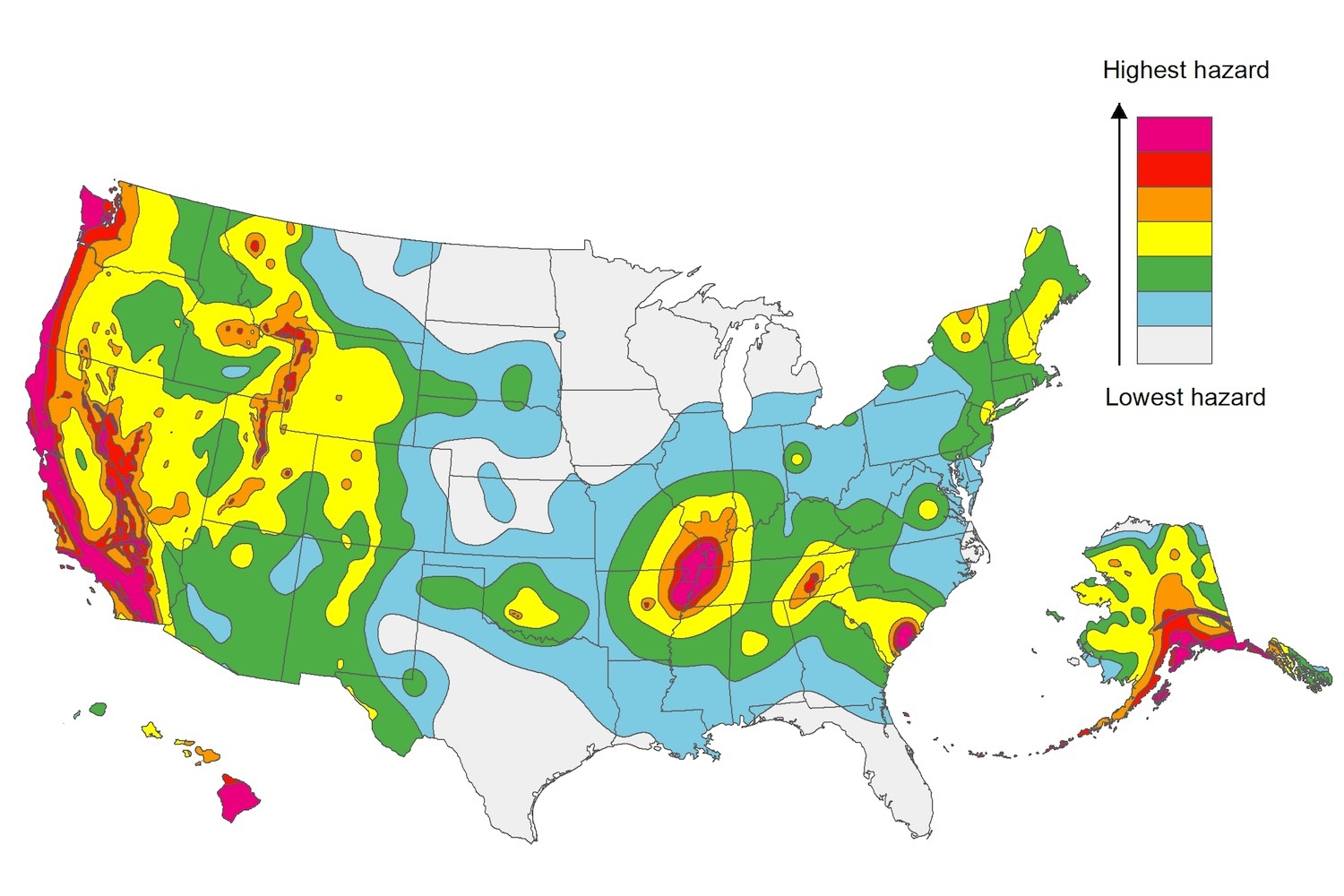
The U.S. Geological Service recently released an update of U.S. National Seismic Hazard Maps that reflect the latest analysis of where future earthquakes will occur, how frequently they may occur, and their strength.
While all states have some potential for earthquakes, 42 of the 50 states have a reasonable chance of experiencing damaging ground shaking from an earthquake in the next 50 years. Sixteen states have a relatively high likelihood of experiencing damaging ground shaking. These states have historically experienced earthquakes with a magnitude 6 or greater. The hazard is especially high along the west coast, intermountain west, and in several active regions elsewhere such as near New Madrid, Mo., and near Charleston, S.C.
The eastern U.S. has the potential for larger and more damaging earthquakes than considered in previous maps and assessments. This finding is due to what scientists learned following the magnitude 5.8 earthquakes that struck Virginia in 2011. It was among the largest earthquakes to occur along the east coast in the last century, and indicated that even larger events in the region are possible.
The maps are used in risk analyses calculated using factors such as population levels, building exposure, and building construction practices. These assessments are used for establishing building codes, in the analysis of seismic risk for key structures, and in determining insurance rates. They can also aid emergency preparedness plans, and private property decisions such as re-evaluating one’s real estate and making it more resilient.
(http://www.usgs.gov/blogs/features/usgs_top_story/new-insight-on-the-nations-earthquake-hazards/)
Related Stories
Codes and Standards | Aug 9, 2017
UpCodes aims to make researching building codes, regulations easier through searchable app
App currently includes building codes of 40 states and New York City.
Codes and Standards | Aug 8, 2017
3D printing industry working to implement standards for products, processes
Additive Manufacturing Standardization Collective (AMSC) will develop industry-wide additive manufacturing standards and specifications.
Codes and Standards | Aug 7, 2017
Council on Tall Buildings and Urban Habitat to create standards to measure floor area
The standards will examine existing codes and regulations to find where they are too broad or contentious.
Codes and Standards | Aug 3, 2017
ASID headquarters is first space in the world to earn both LEED and WELL Platinum Certification
Washington, D.C. office is showcase for top levels of the two standards.
Codes and Standards | Aug 2, 2017
OSHA to release web-based injury and illness reporting form on August 1st
Employers can use the application to submit forms electronically.
Codes and Standards | Aug 1, 2017
Zoning that restricts housing construction also dampens other economic development
Land use restrictions reduce U.S. GDP by 9% annually.
Codes and Standards | Jul 27, 2017
Five fire scenarios tested on full-scale mass timber building
Results will help inform code changes.
Codes and Standards | Jul 26, 2017
New ISO standard on video fire detectors will help identify fires more quickly
The standard marks the first comprehensive international specification for this equipment.
Codes and Standards | Jul 25, 2017
Geotechnical solutions prevent building distress due to expansive clay soils
The condition is the most common geologic hazard in the U.S.
Codes and Standards | Jul 24, 2017
Non-union labor gaining ground in New York City
President of contractors’ group says competitive pricing is spurring more open shops.


