


Four years ago, Massachusetts Institute of Technology’s City Form Lab launched Urban Network Analysis (UNA), a city-modeling software that facilitates a mathematical analysis of relationships among elements in a complex system, like a city. The unique feature of UNA is that it incorporates activities within buildings into its analysis.
This toolbox has been popular with planners and geographers, but it requires ArcGIS10 software with an ArcGIS Network Analysis Extension.
In April, City Form Lab expanded this software’s utility by introducing UNA for Rhino 3D, a modeling software for architects, engineers, and designers.
“Our toolbox helps planners and architects analyze these relationships and quantify how intensely different routes are likely to be utilized, how visible or connected public spaces are, or how conveniently one can get from one space to another,” says Andres Sevtsuk, the principal investigator at City Form Lab and developer of the UNA tool.
In layman’s terms, the software predicts where people are likely to go once they’ve decided upon an activity, like, say, going to an ATM machine or a park. The software provides users with some idea about which ATM or park that would be. As for movements to and within buildings, UNA takes into account employee head count, a building’s value, the surrounding population, and so forth.
This app’s toolbox also computes how urban design can affect—or even dictate—pedestrian movement. Sevtsuk notes, too, that the software can be scaled to account for the diversity of movement in different cities and towns.
Sevtsuk is encouraged by the sheer amount of spatial data available about urban areas, particularly in the U.S., where “you can go to any sizable city website and download data that is necessary to calibrate any of these models.” He’s confident that this software can be used to predict movement in public or semi-public spaces such as building lobbies or shopping centers.
Related Stories

Sponsored | | Nov 26, 2014
Virtual reality in 3D models, iPhone thermal imaging: Inside one very cool tech toybox
A little over a year ago, I embarked on a search to find individuals in the AEC space who were putting new hardware to work in the field.

| Nov 18, 2014
New tool helps developers, contractors identify geographic risk for construction
The new interactive tool from Aon Risk Solutions provides real-time updates pertaining to the risk climate of municipalities across the U.S.

Sponsored | | Nov 12, 2014
Williams Scotsman plugs into the jobsite
Many of our customers conduct important business from their temporary modular jobsite office and most require access to technology to get their job done effectively and efficiently. SPONSORED CONTENT

| Nov 5, 2014
AEC firms leverage custom scripts to bridge the ‘BIM language gap'
Without a common language linking BIM/VDC software platforms, firms seek out interoperability solutions to assist with the data transfer between design tools.
| Nov 3, 2014
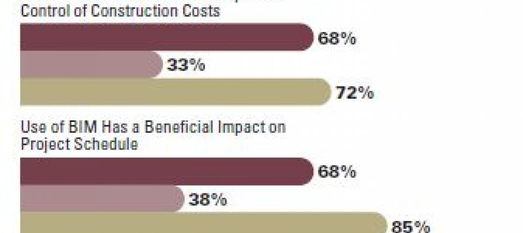
How facility owners can make the most of BIM
More and more facility owners are seeing the benefits that building information modeling can bring to their projects, according to a new McGraw Hill Construction SmartMarket Report, “The Business Value of BIM for Owners.”
| Oct 15, 2014
Drones may soon assist code inspectors for construction in the UAE
The United Arab Emirates’ Ministry of Labour announced that they will start using drones to help inspectors record when construction sites are breaking laws.

| Oct 13, 2014
Debunking the 5 myths of health data and sustainable design
The path to more extensive use of health data in green building is blocked by certain myths that have to be debunked before such data can be successfully incorporated into the project delivery process.

Sponsored | | Oct 13, 2014
William Duff Architects successfully increases revenue while decreasing accounts receivable workload
William Duff Architects has seen immediate benefits to their business since the implementation of ArchiOffice. Within a couple of months, they increased billable staff utilization and reduced accounts receivable workload. SPONSORED CONTENT
| Oct 8, 2014
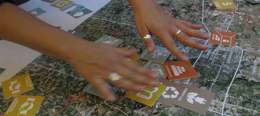
New tools for community feedback and action
Too often, members of a community are put into a reactive position, asked for their input only when a major project is proposed. But examples of proactive civic engagement are beginning to emerge, write James Miner and Jessie Bauters.

| Oct 7, 2014
Structured, not stirred: The architecture of cocktails [infographic]
In this downloadable graphic, technologist Shaan Hurley dissects 37 cocktails and analyzes their architectural makeup.


