


Miami is becoming more and more like New York, and that’s not just due to the migration between the two cities, or the influence that New York developers have in South Florida.
No, Miami is filling out its skyline. With more than 100 new hotel, residential, office, and retail towers and buildings in the development pipeline (projects that could be considered planned, proposed, under construction, or recently completed), the Miami Downtown Development Authority (DDA) launched a new interactive tool to keep track of it all.
The Downtown Miami Interactive 3-D Skyline Map displays depictions of current buildings and the buildings in development on a satellite terrain of downtown Miami and the adjacent Brickell neighborhood. Clicking on a building will bring up a window that tells the address, neighborhood, developer, status, and project description, which includes features, numbers of units, and dimensions and square footage.
Some of the most notable new developments include the Zaha Hadid-designed 1000 Museum, which is currently under construction; the hairpin-shaped Skyrise Miami entertainment and observation tower planned for the waterfront; the 4.9-acre Patricia & Phillip Frost Museum of Science that’s under construction; and the proposed One Bayfront Plaza, an 80-floor tower that will have 700 condos, 620 hotel rooms, and 650,000 sf of office space.
Users can adjust the times of day to see how sunlight and shadows hit buildings. The map also shows zoning boundaries and the routes of the Metrorail rapid transit system.
The DDA will update the map each quarter as buildings are completed and as new projects are announced. The organization has another 2D map that plots all of the projects in development.
Miami certainly has a lot of real estate activity going on. The Miami Herald, which reported in October that the downtown building boom would soon be ending, wrote in late March that the city was beginning a hotel boom. Four new hotels will be built downtown by 2018.
The Wall Street Journal, meanwhile, reported that Miami is on the verge of a condo bust as sales have slipped and inventory tanked. The leak this week of the Panama Papers, which revealed offshore financial dealings, will also hurt Miami’s luxury condo scene.
The Downtown Miami Interactive 3-D Skyline Map can be accessed here.
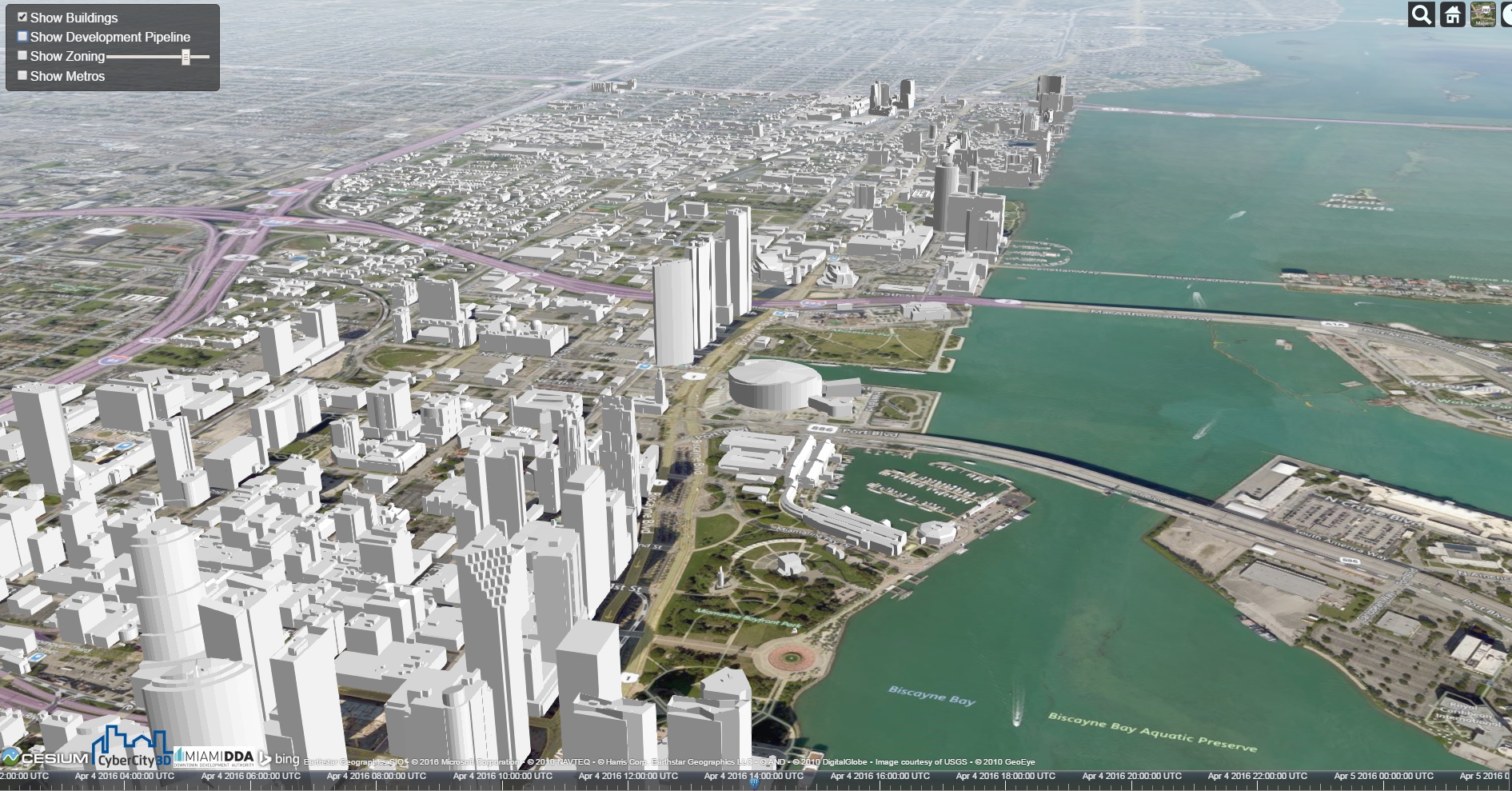 Miami's skyline in 2016.
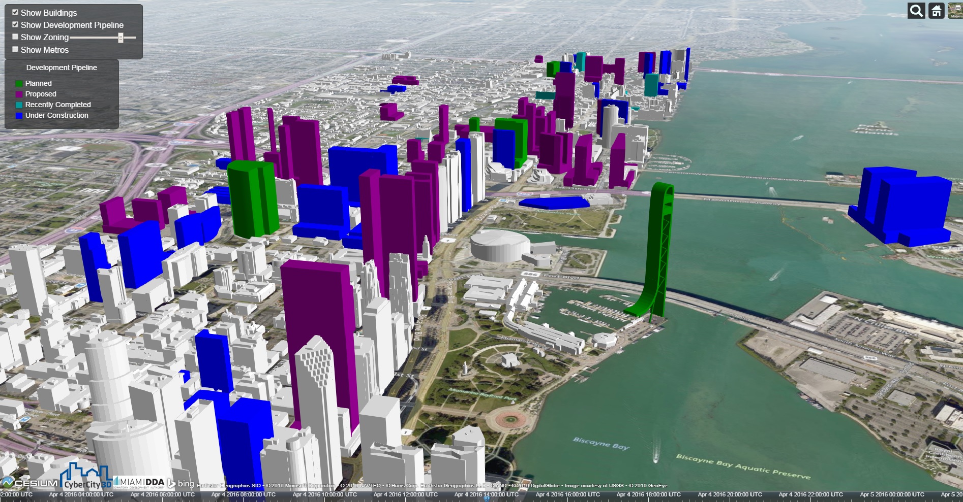 Miami's skyline after projects in development are completed. Click images to enlarge.
Related Stories

Sponsored | BIM and Information Technology | Mar 3, 2015
The great debate: Is 3D PDF really BIM?
You can pull apart buildings, cut through floors, and view simulated animation for assembly instructions all within a PDF.

BIM and Information Technology | Feb 23, 2015
9 best practices for effective laser scanning
JE Dunn’s National BIM Director, Trent Nichols, offers tips and advice for mastering the art of laser scanning.


BIM and Information Technology | Feb 10, 2015
Google's 3D scanning camera leaves the lab
Google is said to be partnering with LG to create a version of the technology for public release sometime this year.

BIM and Information Technology | Feb 8, 2015
BIM for safety: How to use BIM/VDC tools to prevent injuries on the job site
Gilbane, Southland Industries, Tocci, and Turner are among the firms to incorporate advanced 4D BIM safety assessment and planning on projects.

Architects | Feb 5, 2015
Toy around with Ittyblox's ultra-detailed building blocks
For Lego fanatics, time is no object when building a model. For those of us with a little less time, Ittyblox is a good solution.

BIM and Information Technology | Jan 29, 2015
Lego X by Gravity elevates the toy to a digital modeling kit
With the Lego X system, users can transfer the forms they’ve created with legos into real-time digital files.

BIM and Information Technology | Jan 28, 2015
5 crucial lessons from moving BIM/VDC workflows to the cloud
Early adopters of cloud-based model collaboration share what they learned in overcoming their toughest hurdles.

Mixed-Use | Jan 26, 2015
MVRDV designs twisty skyscraper to grace Vienna's skyline
The twist maximizes floor space and decreases the amount of shadows the building will cast on the surrounding area.

| Jan 21, 2015
Schneider Electric and Autodesk begin collaboration on building lifecycle management
Schneider Electric has announced the signature of a Memorandum of Understanding, which states that Schneider Electric and Autodesk plan to collaborate to enhance current practices for building lifecycle management based on BIM.


