

 and the angle at which it was taken, as well as date,")
If it’s true that a picture is worth a thousand words, it’s not surprising that the construction industry loses an untold amount of dollars every year due to poor photo filing. Construction progress photos are worthless if they get filed away without an easy way to locate them, or if you don’t know when and where they were taken.
Commercial construction is extremely complex and becoming more so as we move to combine tens of thousands of supply chains in new synergistic ways—energy recovery systems, variable volume air distribution, and dynamic building controls being a few examples. With all of these moving parts, progress documentation has become essential to the construction process, thus requiring us to take lots of photos. Imagine you could see through walls, above ceilings, and underground, but had no idea where you were looking. That’s roughly the current status of construction progress digital photography.
Let me tell you a story that illustrates my point.
A month after moving a client into a beautiful laboratory building, I received a phone call from one of the facility managers telling me that the exterior lights were out—the breaker had been tripped. We checked the lighting loads and conductors, replaced the breaker, safely reset it, and—ta-da!—the lights worked.
Exactly 30 days later, the same phone call. In desperation I turned to the installation photos. What I found was a mind-numbing pile of digital photos, including one shown here labeled “BOB 005.” The entire collection lacked a meaningful file name, structure, or location. I had no clue as to where the photo belonged or when it was taken. In fact, all the photos had the exact same date, the day the project was closed out.
As it turns out sheer luck led me to the solution. I’ll give you a clue: grey conduit met white conduit and, magically, on the one day in the month when the trees on this desert property were watered, the site lighting would short out. The experience inspired me to find a way to organize digital construction photos so that they could be useful in situations like this.
'Simple isn't the same thing as 'easy'
My first instinct was to try to simplify the process. However, that meant requiring our construction field teams to: 1) take photos of anything that could not be seen after construction; 2) download the photos on a regular basis; 3) name and date the photos in such a way that a third party could find their way back to the point of reference where the photo was taken; and 4) make the photos truly searchable.
This first idea was to develop a complex file structure that was located on a project SharePoint site. The idea was that each folder would hold only photos of that specific room, product, or site location; anyone could post and use the library at any time in the future.
As you’ve probably guessed, my plan fell short at the implementation stage. The operations group members weren’t downloading photos on a regular basis, couldn’t remember where photos had been taken, and didn’t post them into the correct folder. As a fallback, I thought about hiring a couple of project interns whose only job would be to document photos, but that, too, would have been too labor intensive.
What we needed was a solution that didn’t add labor costs and would actually encourage our field staff to take construction progress photos. In short, we needed a tool that could see through walls, above ceilings, and underground—a tool where all the pertinent information could be automatically stored with the photo the moment it was taken.
Increasing the level of photo sophistication
I won’t keep you in suspense any longer. The solution turned out to be “geo-tagging,” which is the process of adding geographical identification metadata to images through a global positioning system (GPS) digital camera. Such cameras are all over the market. We tested Nikon’s P6000, Samsung’s CL65, and several models by Sony; we chose the Sony Cybershot DSC-HX5 for its reasonable cost, GPS accuracy, and the fact that it utilizes a nonproprietary memory card that could easy be removed to transfer photos onto our project servers.
The data-rich file itself is not the end-all; it’s what you can do with it that counts. To draw a parallel, a digital song file comes with the image of the album cover, the name of the song, the artist, and the date it was recorded. It doesn’t matter what kind of device you play a digital song on, you still have access to the data.
Similarly, a geo-tagged photo comes with its latitude, longitude, altitude, compass direction, date, and time recorded. Having all that data embedded in your geo-tagged photos allows you to create so-called “mashups.”
According to Wikipedia 2012, a mashup is “a Web page or application that uses and combines data, presentation, or functionality from two or more sources to create new services.” The main characteristics of mashups are “combination, visualization, and aggregation” that make existing data more useful for professional (or personal) use.
When a construction progress photo has been geo-tagged, it can be viewed in any of a number of mapping programs that recognize latitude and longitude; with a little work, it can even be viewed in programs that recognize x-y-z relationships to a given reference point.
One of the simplest of these mapping programs is Google Maps. In the case of the geo-tagged photo and Google Maps mashup on page 21, the red pin represents the precise location where the photo was taken. The blue cone emanating from the pin is the image angle, indicating the direction of the photo. In other words, the person taking the photo was standing on the red pin and facing in the direction of the blue triangle.
Once your photos have been geo-tagged they can be paired (i.e., mashed) with any number of backgrounds through a variety of interfaces. The three primary interfaces that we use are: 1) the typical file view (sort by name or date); 2) a very useful calendar view; and 3) a map view.
Finding your construction progress photos now becomes much easier. If you know the approximate date, use the calendar view. If you know roughly the location, use the map view. Let’s say you are a supervisor of several construction projects, and you want to find a photo from your job in Phoenix. No problem: using the software that comes with the GPS camera, just zoom in to the location.
Moreover, you don’t necessarily need a GPS-enabled camera to geo-tag your photos. You can download freeware (e.g., Picasa 3, GeoSetter, Geolmgr) that will enable you to manually geo-tag your new (and old) photos that were taken with a non-GPS-enabled camera. Using the map view, you simply drag and drop your photos to the location you remember being at.
However, this method makes you do all the manual work yourself, which from a field perspective creates a disincentive for taking project progress photos
The most elegant solutions are often the simplest. In the brave new world of open source data and cloud computing, data sophistication is paramount. Thanks to GPS and digital cameras, now you can see through walls, above ceilings, and below ground, as if you were really there. +
Ryan Abbott (raabbott@sundt.com) is the Science & Technology Group Leader with SUNDT Construction, Inc.
Related Stories

Headquarters | May 16, 2023
Workplace HQ for party clothing company Shinesty celebrates its bold, whimsical products
The new Denver headquarters for Shinesty, a party clothing company, was designed to match the brand’s fun image with an iconic array of colors, textures, and prints curated by the design agency, Maximalist. Shinesty’s mission, to challenge the world to live more freely and “take itself less seriously,” is embodied throughout the office interior.

Office Buildings | May 15, 2023
Sixteen-story office tower will use 40% less energy than an average NYC office building
This month marks the completion of a new 16-story office tower that is being promoted as New York City’s most sustainable office structure. That boast is backed by an innovative HVAC system that features geothermal wells, dedicated outdoor air system (DOAS) units, radiant heating and cooling, and a sophisticated control system to ensure that the elements work optimally together.

Life of an Architect Podcast | May 15, 2023
Life of an Architect Podcast Ep. 125: What Makes a Great Employee?
How do you define a great employee? The answer is most likely dependent on who is attempting to respond: the employee or the employer. Life of an Architect's Bob Borson, FAIA, and Andrew Hawkins, AIA, talk about the traits and characteristics of great employees.

K-12 Schools | May 12, 2023
In Virginia, a new high school building helps reimagine the experience for 1,600 students
In Virginia, the City of Alexandria recently celebrated the topping out of a new building for Alexandria City High School. When complete in 2025, the high-performance structure will accommodate 1,600 students.

University Buildings | May 11, 2023
New ‘bold and twisting’ building consolidates School of Continuing Studies at York University
The design of a new building that consolidates York University’s School of Continuing Studies into one location is a new architectural landmark at the Toronto school’s Keele Campus. “The design is emblematic of the school’s identity and culture, which is centered around accelerated professional growth in the face of a continuously evolving labor market,” according to a news release from Perkins&Will.

Sustainability | May 11, 2023
Let's build toward a circular economy
Eric Corey Freed, Director of Sustainability, CannonDesign, discusses the values of well-designed, regenerative buildings.

Hotel Facilities | May 9, 2023
A new camping destination near Utah’s Zion National Park offers a variety of all-season lodgings and amenities
Outdoor lodging brand AutoCamp has opened a new camping destination near Utah’s Zion National Park. A 16-acre property, AutoCamp Zion is located between the Virgin River and the desert of Southern Utah.
Headquarters | May 9, 2023
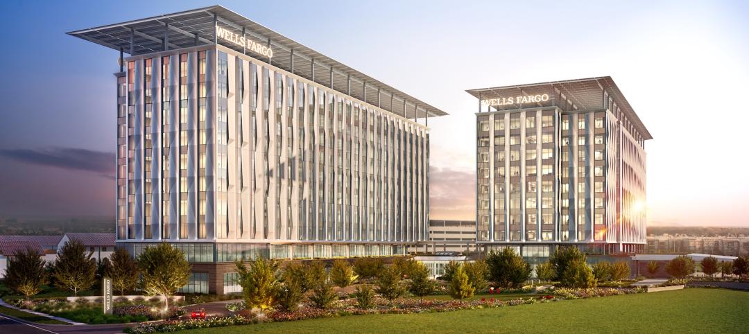
New Wells Fargo development in Texas will be bank’s first net-positive campus
A new Wells Fargo development in the Dallas metroplex will be the national bank’s first net-positive campus, expected to generate more energy than it uses. The 850,000-sf project on 22 acres will generate power from solar panels and provide electric vehicle charging stations.

Regulations | May 8, 2023
Supreme Court case likely to have huge impact on Clean Water Act
A case before the Supreme Court will likely determine how the Clean Water Act is interpreted and the ruling could open up new areas for development within or adjacent to wetlands.

Senior Living Design | May 8, 2023
Seattle senior living community aims to be world’s first to achieve Living Building Challenge designation
Aegis Living Lake Union in Seattle is the world’s first assisted living community designed to meet the rigorous Living Building Challenge certification. Completed in 2022, the Ankrom Moisan-designed, 70,000 sf-building is fully electrified. All commercial dryers, domestic hot water, and kitchen equipment are powered by electricity in lieu of gas, which reduces the facility’s carbon footprint.


