

 and the angle at which it was taken, as well as date,")
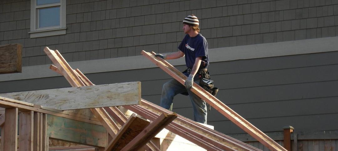
If it’s true that a picture is worth a thousand words, it’s not surprising that the construction industry loses an untold amount of dollars every year due to poor photo filing. Construction progress photos are worthless if they get filed away without an easy way to locate them, or if you don’t know when and where they were taken.
Commercial construction is extremely complex and becoming more so as we move to combine tens of thousands of supply chains in new synergistic ways—energy recovery systems, variable volume air distribution, and dynamic building controls being a few examples. With all of these moving parts, progress documentation has become essential to the construction process, thus requiring us to take lots of photos. Imagine you could see through walls, above ceilings, and underground, but had no idea where you were looking. That’s roughly the current status of construction progress digital photography.
Let me tell you a story that illustrates my point.
A month after moving a client into a beautiful laboratory building, I received a phone call from one of the facility managers telling me that the exterior lights were out—the breaker had been tripped. We checked the lighting loads and conductors, replaced the breaker, safely reset it, and—ta-da!—the lights worked.
Exactly 30 days later, the same phone call. In desperation I turned to the installation photos. What I found was a mind-numbing pile of digital photos, including one shown here labeled “BOB 005.” The entire collection lacked a meaningful file name, structure, or location. I had no clue as to where the photo belonged or when it was taken. In fact, all the photos had the exact same date, the day the project was closed out.
As it turns out sheer luck led me to the solution. I’ll give you a clue: grey conduit met white conduit and, magically, on the one day in the month when the trees on this desert property were watered, the site lighting would short out. The experience inspired me to find a way to organize digital construction photos so that they could be useful in situations like this.
'Simple isn't the same thing as 'easy'
My first instinct was to try to simplify the process. However, that meant requiring our construction field teams to: 1) take photos of anything that could not be seen after construction; 2) download the photos on a regular basis; 3) name and date the photos in such a way that a third party could find their way back to the point of reference where the photo was taken; and 4) make the photos truly searchable.
This first idea was to develop a complex file structure that was located on a project SharePoint site. The idea was that each folder would hold only photos of that specific room, product, or site location; anyone could post and use the library at any time in the future.
As you’ve probably guessed, my plan fell short at the implementation stage. The operations group members weren’t downloading photos on a regular basis, couldn’t remember where photos had been taken, and didn’t post them into the correct folder. As a fallback, I thought about hiring a couple of project interns whose only job would be to document photos, but that, too, would have been too labor intensive.
What we needed was a solution that didn’t add labor costs and would actually encourage our field staff to take construction progress photos. In short, we needed a tool that could see through walls, above ceilings, and underground—a tool where all the pertinent information could be automatically stored with the photo the moment it was taken.
Increasing the level of photo sophistication
I won’t keep you in suspense any longer. The solution turned out to be “geo-tagging,” which is the process of adding geographical identification metadata to images through a global positioning system (GPS) digital camera. Such cameras are all over the market. We tested Nikon’s P6000, Samsung’s CL65, and several models by Sony; we chose the Sony Cybershot DSC-HX5 for its reasonable cost, GPS accuracy, and the fact that it utilizes a nonproprietary memory card that could easy be removed to transfer photos onto our project servers.
The data-rich file itself is not the end-all; it’s what you can do with it that counts. To draw a parallel, a digital song file comes with the image of the album cover, the name of the song, the artist, and the date it was recorded. It doesn’t matter what kind of device you play a digital song on, you still have access to the data.
Similarly, a geo-tagged photo comes with its latitude, longitude, altitude, compass direction, date, and time recorded. Having all that data embedded in your geo-tagged photos allows you to create so-called “mashups.”
According to Wikipedia 2012, a mashup is “a Web page or application that uses and combines data, presentation, or functionality from two or more sources to create new services.” The main characteristics of mashups are “combination, visualization, and aggregation” that make existing data more useful for professional (or personal) use.
When a construction progress photo has been geo-tagged, it can be viewed in any of a number of mapping programs that recognize latitude and longitude; with a little work, it can even be viewed in programs that recognize x-y-z relationships to a given reference point.
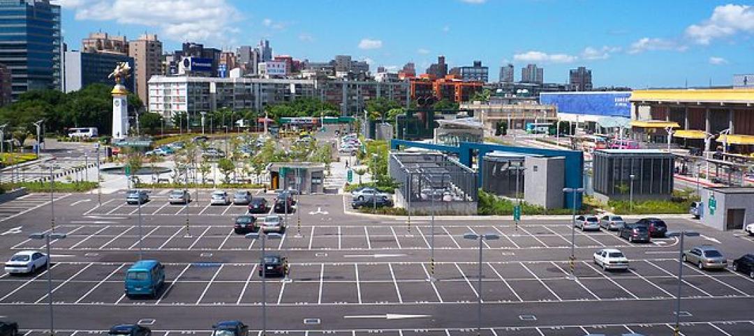
One of the simplest of these mapping programs is Google Maps. In the case of the geo-tagged photo and Google Maps mashup on page 21, the red pin represents the precise location where the photo was taken. The blue cone emanating from the pin is the image angle, indicating the direction of the photo. In other words, the person taking the photo was standing on the red pin and facing in the direction of the blue triangle.
Once your photos have been geo-tagged they can be paired (i.e., mashed) with any number of backgrounds through a variety of interfaces. The three primary interfaces that we use are: 1) the typical file view (sort by name or date); 2) a very useful calendar view; and 3) a map view.
Finding your construction progress photos now becomes much easier. If you know the approximate date, use the calendar view. If you know roughly the location, use the map view. Let’s say you are a supervisor of several construction projects, and you want to find a photo from your job in Phoenix. No problem: using the software that comes with the GPS camera, just zoom in to the location.
Moreover, you don’t necessarily need a GPS-enabled camera to geo-tag your photos. You can download freeware (e.g., Picasa 3, GeoSetter, Geolmgr) that will enable you to manually geo-tag your new (and old) photos that were taken with a non-GPS-enabled camera. Using the map view, you simply drag and drop your photos to the location you remember being at.
However, this method makes you do all the manual work yourself, which from a field perspective creates a disincentive for taking project progress photos
The most elegant solutions are often the simplest. In the brave new world of open source data and cloud computing, data sophistication is paramount. Thanks to GPS and digital cameras, now you can see through walls, above ceilings, and below ground, as if you were really there. +
Ryan Abbott (raabbott@sundt.com) is the Science & Technology Group Leader with SUNDT Construction, Inc.
Related Stories
| Dec 22, 2014
What Building Teams can learn from home builders' travails
Commercial and residential construction can be as different as night and day. But as one who covered the housing industry for nearly a decade, I firmly believe AEC firms can learn some valuable lessons from the trials and tribulations that home builders experienced during the Great Recession, writes BD+C's John Caulfield.

| Dec 22, 2014
Skanska to build Miami’s Patricia and Phillip Frost Museum of Science
Designed by Grimshaw Architects, the 250,000-sf museum will serve as an economic engine and cultural anchor for Miami’s fast-growing urban core.

| Dec 22, 2014
Studio Gang to design Chicago’s third-tallest skyscraper
The first U.S. real-estate investment by The Wanda Group, owned by China’s richest man, will be an 88-story, 1,148-ft-tall mixed-use tower designed by Jeanne Gang.

| Dec 19, 2014
Zaha Hadid unveils dune-shaped HQ for Emirati environmental management company
Zaha Hadid Architects released designs for the new headquarters of Emirati environmental management company Bee’ah, revealing a structure that references the shape and motion of a sand dune.

| Dec 19, 2014
Chicago Architecture Biennial to hold 'Lakefront Kiosk Competition'
The first Chicago Architecture Biennial will take place from October 2015-January 2016, with a theme of "The State of the Art of Architecture."

| Dec 18, 2014
Frank Lloyd Wright's Taliesin West to be recreated—with LEGO
Containing more than 180,000 LEGO bricks in 11 colors and 120 different shapes, the model measures eight by four feet and is made entirely of standard LEGO parts.

| Dec 18, 2014
11 new highs for tall buildings: CTBUH recaps the year's top moments in skyscraper construction
The Council on Tall Buildings and Urban Habitat cherrypicked the top moments from 2014, including a record concrete pour, a cautionary note about high-rise development, and two men's daring feat.
| Dec 18, 2014
International Parking Institute and Green Parking Council collaborate with GBCI
The new collaboration recognizes importance of sustainable parking facility design and management to the built environment.
| Dec 18, 2014
Top 10 sports facilities of 2014: Designboom ranks the year's best projects
The list includes some of the year's epic stadiums, such as World Cup Stadium Arena de Amazonia in Manaus, Brazil, and smaller projects, like the Spordtgebouw Sports Centerin the Netherlands.

| Dec 18, 2014
In response to ultra-open and uber-collaborative office environments
Susan Cain’s bestselling 2012 book, "Quiet: The Power of Introverts in a World That Can’t Stop Talking" has made an impact on how we understand our current workforce, recognizing that at least one-third of the people we work with are introverts, writes SRG Partnership's Susan Gust.


