

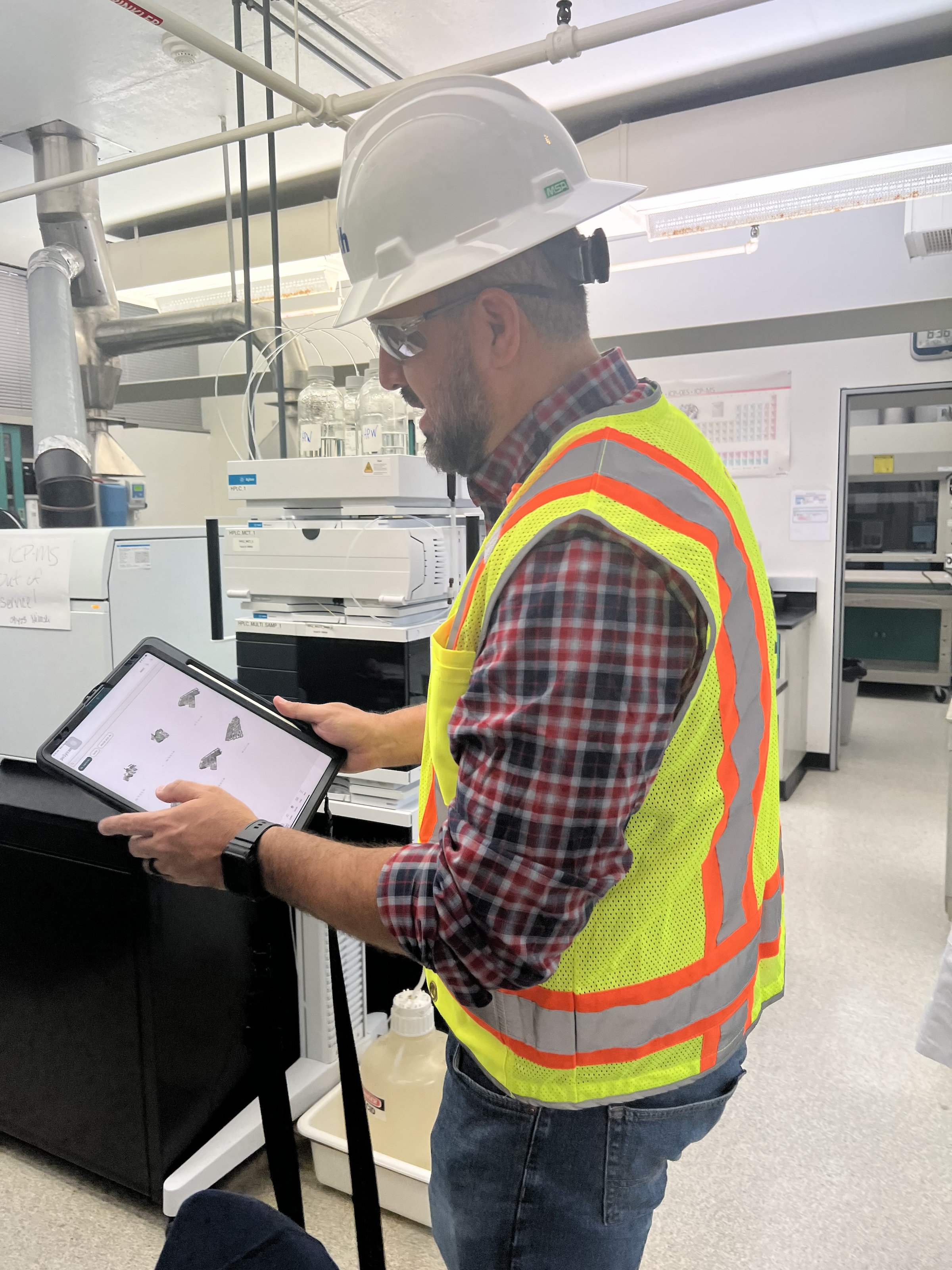
 in Virginia Beach, Va., used LIDAR and BIM technology to develop precise building and equipment data for a planned expansion of its Central Environmental Laboratory. Photo courtesy CDM Smith")
In the world of architecture and engineering, laboratory buildings are among the most complex buildings to design, plan, and document. Traditional methods rely on the use of photographs, hand drawings, or notes to document not only the building but also the equipment that makes up a laboratory. This makes the process difficult, tedious, time consuming, and even allows for documentation errors.
Currently, the most advanced state-of-the-art technology is combining Light Detection and Ranging (LIDAR) technology with Building Information Modeling (BIM) technology. LIDAR is a remote sensing method that uses light in the form of a pulsed laser to measure ranges to Earth. BIM is workflow process software used to model and optimize projects.
The latest LIDAR technology is available in the current version of hand-held devices that are used for field documentation. These devices come equipped with a very reliable LIDAR scanner, which allows one to easily document and scan in a point cloud all the existing conditions of the building like its space, function, and mechanical, electrical, and plumbing (MEP) needs.
Following the LIDAR scan, advanced software is deployed to transfer the data into a point cloud. This serves as a reliable reference to take measurements, to know where equipment is, and what its MEP needs are. Once in the point cloud, it is then exported into Autodesk ReCap Pro, and later to Autodesk Revit, which are BIM solutions.
Here it is not only inserted into the point cloud to corroborate measurements, locations and needs. It is also with the use of BIM technology and the use of special equipment families, that the foundations for the use of 7D Management of the laboratory equipment and MEP items can be developed into a 7D BIM Model.
A digital twin, which is a digital representation of a physical object or process in a digital version of its environment, can also be developed from this point. Digital twins can help an organization simulate real situations and their outcomes, ultimately allowing it to make better decisions.
LIDAR and BIM technology for building data collection
LIDAR and BIM technology such as Revit allows the existing conditions captured on site to be preserved in the digital model, allowing for measurements, orientation to aspects of the model, etc. without having to be physically on site, and more importantly, to have an orientation as to where each piece of equipment is and what the MEP needs are.
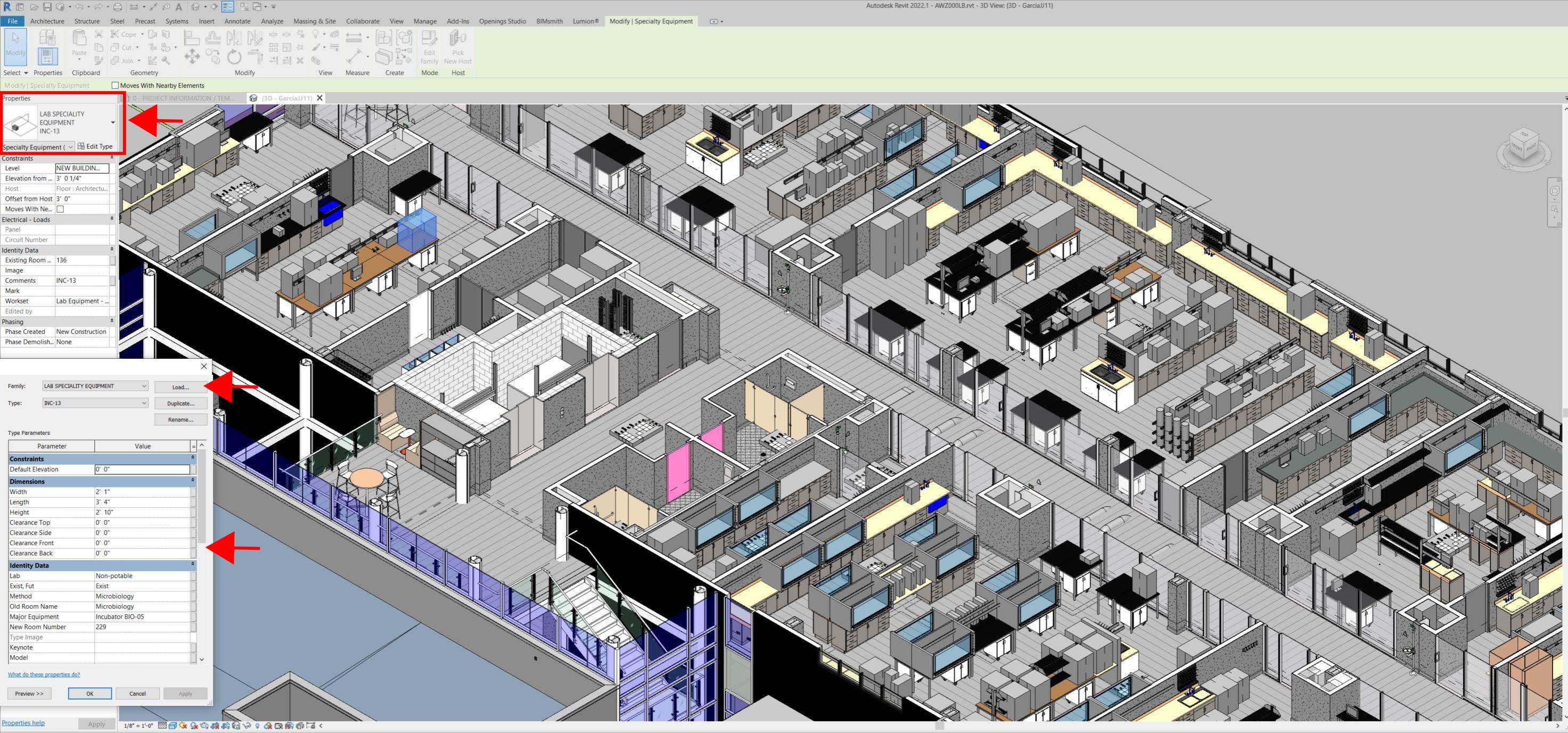
Even for any highly experienced architect or BIM modeler, just using photographs or hand drawings can be overwhelming and very complicated. Using this process, the Revit model serves as a replica of the existing conditions of each space and equipment. During a building expansion, being able to compare existing equipment in the new space is more accurate and easier to understand.
For example, Hampton Roads Sanitation District (HRSD) in Virginia Beach, Va., used LIDAR and BIM technology to develop precise building and equipment data for a planned expansion of its Central Environmental Laboratory.
The process involved meticulously scanning each space relevant to the project. This comprehensive scan aimed to capture every corner accurately. Following the scanning phase, the data was processed, generating a point cloud in ReCap Pro format. With the point cloud, we harnessed the advantages of LIDAR technology such as digitally acquiring existing conditions of the building and equipment, essentially providing a virtual on-site experience with just a click, eliminating the need for physical site visits.
This technology has enabled us to create detailed digital 3D families for every existing piece of equipment and its needs, as well as to capture more accurate existing conditions for the building. In the past, our approach relied solely on on-site measurements and photographs, leading to continuous errors and laborious, time-consuming tasks.
The previous method also necessitated numerous site visits for data verification. The implementation of this advanced technology and streamlined process has not only saved time and money but has also significantly enhanced our efficiency. For instance, all of that work required in the past to digitally model from notes, photographs, existing building plans, etc. has been condensed to the import and refinement of the point cloud data into the modeling environment.
Related Stories
| Aug 11, 2010
USGBC honors Brad Pitt's Make It Right New Orleans as the ‘largest and greenest single-family community in the world’
U.S. Green Building Council President, CEO and Founding Chair Rick Fedrizzi today declared that the neighborhood being built by Make It Right New Orleans, the post-Katrina housing initiative launched by actor Brad Pitt, is the “largest and greenest community of single-family homes in the world” at the annual Clinton Global Initiative meeting in New York.
| Aug 11, 2010
AIA report estimates up to 270,000 construction industry jobs could be created if the American Clean Energy Security Act is passed
With the encouragement of Senate majority leader Harry Reid (D-NV), the American Institute of Architects (AIA) conducted a study to determine how many jobs in the design and construction industry could be created if the American Clean Energy Security Act (H.R. 2454; also known as the Waxman-Markey Bill) is enacted.
| Aug 11, 2010
Nation's first set of green building model codes and standards announced
The International Code Council (ICC), the American Society of Heating, Refrigerating and Air Conditioning Engineers (ASHRAE), the U.S. Green Building Council (USGBC), and the Illuminating Engineering Society of North America (IES) announce the launch of the International Green Construction Code (IGCC), representing the merger of two national efforts to develop adoptable and enforceable green building codes.
| Aug 11, 2010
More construction firms likely to perform stimulus-funded work in 2010 as funding expands beyond transportation programs
Stimulus funded infrastructure projects are saving and creating more direct construction jobs than initially estimated, according to a new analysis of federal data released today by the Associated General Contractors of America. The analysis also found that more contractors are likely to perform stimulus funded work this year as work starts on many of the non-transportation projects funded in the initial package.
| Aug 11, 2010
Broadway-style theater headed to Kentucky
One of Kentucky's largest performing arts venues should open in 2011—that's when construction is expected to wrap up on Eastern Kentucky University's Business & Technology Center for Performing Arts. The 93,000-sf Broadway-caliber theater will seat 2,000 audience members and have a 60×24-foot stage proscenium and a fly loft.
| Aug 11, 2010
Citizenship building in Texas targets LEED Silver
The Department of Homeland Security's new U.S. Citizenship and Immigration Services facility in Irving, Texas, was designed by 4240 Architecture and developed by JDL Castle Corporation. The focal point of the two-story, 56,000-sf building is the double-height, glass-walled Ceremony Room where new citizens take the oath.


