

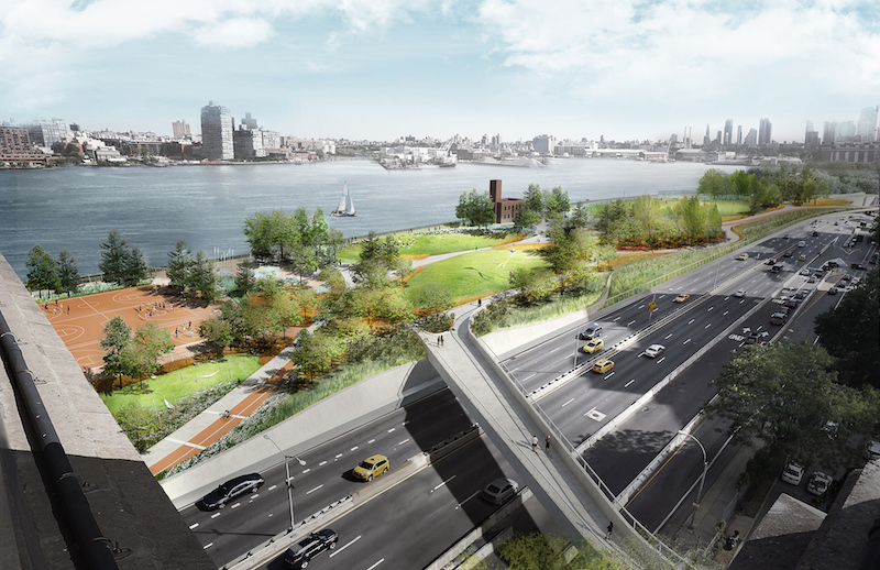
Led by the Mayor’s Office of Recovery and Resiliency, the East Side Coastal Resiliency (ESCR) Project is an urban flood protection solution that spans 2.5 miles of Lower Manhattan, including the East Side. The project is the first element of coastal storm and sea level rise defense system for the East Side and Lower Manhattan.
Arcadis, a design and consultancy firm for natural and built habitats, will work in collaboration with the City of New York and local communities to design flood protection solutions that merge into the urban fabric for 200,000 residents and 21,000 businesses. The solutions will strengthen the coastal defenses and improve existing parks while offering future flood protection and environmental benefits.
Design features of the project will incorporate a combination of architectural floodwalls, bridging berms, embankments, moveable floodgates, and interior drainage improvements. Each of these new features will be integrated with East River Park amenities to include recreational facilities and pedestrian and bicycle pathways.
Additionally, Arcadis will develop supporting documentation necessary for changes to FEMA flood hazard maps. Bjarke Ingels Group is leading the Urban design for the project with Starr Whithouse providing landscape architecture services. CH2M Hill will handle marine engineering duties.
Related Stories

Resiliency | Jan 13, 2016
LEED credits on resiliency expected to influence future of building design
Post-disaster survivability is a key goal.


Resiliency | Dec 7, 2015
New earthquake rating system released by the U.S. Resiliency Council
Intended for building owners and leasing, finance, and insurance industry.


