Drones take site assessments to new heights
New technologies for visualization and reality capture are expanding what the AEC industry can do when assessing a site—an often-arduous task that doesn’t always capture the big picture or the small details. While photos and drawings can offer a small glimpse of an overall site, it can be challenging to visualize and understand how all elements relate to one another.
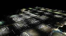
Drones can be particularly helpful when assessing a building’s lighting and security and pointing out areas of vulnerability. By flying drones at night, we can see an enhanced view of a building and the owners’ entire site. We look at their lighting and identify where there may be gaps that cause security issues. We gather the data points to create a 3D model that we can show clients and design team members to help visually communicate the challenges and how we can help solve them.
Benefits of drone software
This visualization and reality capture can provide accurate and current information about existing sites, buildings, lighting, and other elements quickly, safely, and cost-effectively. With such accuracy, the data provided can help our clients with tasks like cost estimating, can capture visual components outside the scope of work or on adjacent site considerations, and provide greater operational safety since people do not need to be put in dangerous situations to gather the data.
We recently did a night drone flight for a client in Denver to provide a lighting and security assessment to address potential safety concerns. We used multiple technologies including GPS, a 360-degree camera, illuminance meter, and drone to capture visual, spatial, and light measurements within the site. We then leveraged GIS to combine the data collected and supplement our reporting. The results were highly visual and included a heat map of the lighting measurements, night-time aerial image overlay, and photograph locations. We delivered this to the client with our notes and suggestions for improving lighting and security.
I’ll be presenting on this topic with my colleagues Shanna Olson, Architectural Lighting Leader, and Ryan Searles, Security Consulting Group Leader, at the annual AIA conference this June. Our presentation, “Enhanced Visualization & Reality Capture from a Bird’s Eye View” will be at 4 p.m. June 9, and we’ll be sharing some cool new drone footage and strategies for using visualization and reality capture.
You can also listen to a podcast we recorded about some of the innovative technology we’re using for our site assessments:
