


Leica Geosystems announced the industry’s first commercially available wearable reality-capture technology with the Pegasus:Backpack at HxGN LIVE.
Combining five high-dynamic cameras, which work in a variety of light conditions, and a LiDAR profiler with an ultra-light and ergonomic carbon fiber chassis, this mobile mapping solution creates a 3D view indoors or outdoors for engineering or professional documentation creation at the highest level of authority yet.
For BIM or simply for capturing 2D square foot updates to a large building, the Leica Pegasus:Backpack creates the most realistic view by capturing synchronized imagery and point cloud data. Accurate positioning is achieved in GNSS-restricted areas using Simultaneous Localization and Mapping, or SLAM, technology. Together with a high precision inertial measurement unit, the Leica Pegasus:Backpack is the first position-agnostic solution.
This new technology is designed to enable weekly data capture efficiently and cost effectively for changing building construction sites. For the first time, this enables the creation of a full starting document for authoritative 6D management of a building or simply to provide an authoritative hand-off dataset to a new building owner. By capturing weekly during a building’s construction, an “x-ray” view of the building is created. As the Backpack clearly logs position and time with the advanced measurement of LiDAR, change orders in the construction process can now offer a complete new level of authority for quality construction while scheduled milestones are achieved.
With full 360-spherical views and LiDAR together plus a hardware light sensor, all images are usable while other functions are verifiable and adjustable over the operator’s tablet device. The system uses multiple hot-swappable batteries, making even long captures possible.
“With the Leica Pegasus:Backpack, limited-access outdoor areas or underground infrastructures are no longer limited in professional data collection,” said Stuart Woods, Geospatial Solutions Division vice-president. “Users will never again forget any aspect of any job nor need to return to a project site. They can capture everything by simply arriving on site wearing the technology, capture and leave, rest assured they have everything they need to complete the job on time and on budget.”
Working with images and point clouds together, data is captured into a single platform and workflow – from the operator interface to a single-click post-processing to feature Meta tagging. Leveraging Leica’s Mapfactory extension, features can be extracted and datasets can be exported to CAD or BIM specific software solutions. More effective decision making is finally achieved with 3D spatial models that allow for true life cycle building planning, enabling 6D BIM.
Related Stories

| Nov 18, 2014
New tool helps developers, contractors identify geographic risk for construction
The new interactive tool from Aon Risk Solutions provides real-time updates pertaining to the risk climate of municipalities across the U.S.
Sponsored | | Nov 12, 2014
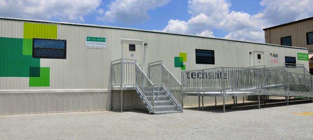
Williams Scotsman plugs into the jobsite
Many of our customers conduct important business from their temporary modular jobsite office and most require access to technology to get their job done effectively and efficiently. SPONSORED CONTENT

| Nov 5, 2014
AEC firms leverage custom scripts to bridge the ‘BIM language gap'
Without a common language linking BIM/VDC software platforms, firms seek out interoperability solutions to assist with the data transfer between design tools.
| Nov 3, 2014
How facility owners can make the most of BIM
More and more facility owners are seeing the benefits that building information modeling can bring to their projects, according to a new McGraw Hill Construction SmartMarket Report, “The Business Value of BIM for Owners.”
| Oct 15, 2014
Drones may soon assist code inspectors for construction in the UAE
The United Arab Emirates’ Ministry of Labour announced that they will start using drones to help inspectors record when construction sites are breaking laws.

| Oct 13, 2014
Debunking the 5 myths of health data and sustainable design
The path to more extensive use of health data in green building is blocked by certain myths that have to be debunked before such data can be successfully incorporated into the project delivery process.

Sponsored | | Oct 13, 2014
William Duff Architects successfully increases revenue while decreasing accounts receivable workload
William Duff Architects has seen immediate benefits to their business since the implementation of ArchiOffice. Within a couple of months, they increased billable staff utilization and reduced accounts receivable workload. SPONSORED CONTENT

| Oct 8, 2014
New tools for community feedback and action
Too often, members of a community are put into a reactive position, asked for their input only when a major project is proposed. But examples of proactive civic engagement are beginning to emerge, write James Miner and Jessie Bauters.

| Oct 7, 2014
Structured, not stirred: The architecture of cocktails [infographic]
In this downloadable graphic, technologist Shaan Hurley dissects 37 cocktails and analyzes their architectural makeup.

Sponsored | | Sep 30, 2014
What are you doing to win business and improve morale?? VDC Director Kris Lengieza shares ways to do both
Bluebeam's Sasha Reed sits down with Kris Lengieza, Director of Virtual Design and Construction for Stiles Corporation, to learn how he approaches change management. SPONSORED CONTENT


